IMAGES TAKEN NEAR TO
Lovers Lane, BRAINTREE, CM7 4AP
Introduction
This page details the photographs taken nearby to Lovers Lane, CM7 4AP by members of the Geograph project.
The Geograph project started in 2005 with the aim of publishing, organising and preserving representative images for every square kilometre of Great Britain, Ireland and the Isle of Man.

There are currently over 7.5m images from over14,400 individuals and you can help contribute to the project by visiting https://www.geograph.org.uk
Image Map
Images are licensed for reuse under creativecommons.org/licenses/by-sa/2.0
Notes
- Clicking on the map will re-center to the selected point.
- The higher the marker number, the further away the image location is from the centre of the postcode.
Image Listing (2 Images Found)
Images are licensed for reuse under creativecommons.org/licenses/by-sa/2.0
Image
Details
Distance
1
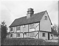
Timbers Cottage at Cherry Gardens, Wethersfield
This tudor house was built in the 1600s. The picture was taken by my wife when she lived in the cottage in the mid 1950s. Located just over a mile south of Wethersfield on the B1053 road, on the way to Braintree.
Image: © R Diane Drummond Sasiela
Taken: Unknown
0.09 miles
2

Direction Sign ? Signpost
Located in a hedge beside a gate on the north side of the T junction at Tinkers Cross in Wethersfield parish. 2 missing arms and cone finial.
Milestone Society National ID: EX_TL7230
Image: © M Bardell
Taken: 24 Mar 2020
0.18 miles