IMAGES TAKEN NEAR TO
High Street, DUNMOW, CM6 3SQ
Introduction
This page details the photographs taken nearby to High Street, CM6 3SQ by members of the Geograph project.
The Geograph project started in 2005 with the aim of publishing, organising and preserving representative images for every square kilometre of Great Britain, Ireland and the Isle of Man.

There are currently over 7.5m images from over14,400 individuals and you can help contribute to the project by visiting https://www.geograph.org.uk
Image Map
Images are licensed for reuse under creativecommons.org/licenses/by-sa/2.0
Notes
- Clicking on the map will re-center to the selected point.
- The higher the marker number, the further away the image location is from the centre of the postcode.
Image Listing (16 Images Found)
Images are licensed for reuse under creativecommons.org/licenses/by-sa/2.0
Image
Details
Distance
1
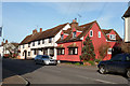
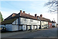
Houses on Stebbing High Street
The far two light coloured buildings are grade II listed. The oldest parts of the timbered building are 15th century.
Image: © Robin Webster
Taken: 11 Jan 2015
0.03 miles
2
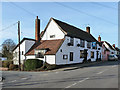
The White Hart, Stebbing
A grade II listed building, 17th century and earlier, on the west side of the High Street.
Image: © Robin Webster
Taken: 11 Jan 2015
0.04 miles
3
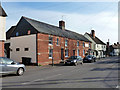
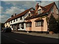
Houses on Stebbing High Street
The brick row and the house beyond are grade II listed buildings. The far house is of Town Farm, 16th century. The brick row has 19th century brickwork over probably a 17th century core. Bell House, this end, was originally a pub. The far end was at some stage a butchers, which accounts for the bay frontage and the light rectangle, now unlettered.
Image: © Robin Webster
Taken: 11 Jan 2015
0.06 miles
4
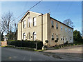
Former chapel, Mill Lane, Stebbing
The former Congregational Chapel is now divided into flats.
Image: © Robin Webster
Taken: 11 Jan 2015
0.07 miles
5
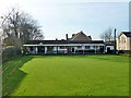
Stebbing Bowling Club
On the corner of High Street and Mill Lane.
Image: © Robin Webster
Taken: 11 Jan 2015
0.07 miles
6
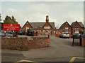
Stebbing Primary School, Stebbing, Essex
Image: © Robert Edwards
Taken: 13 Sep 2006
0.07 miles
7
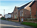
Stebbing Village Hall
This is a grade II listed building built 1877, listed as 'United Reformed Church' but oddly not appearing on older maps as a church or chapel, although it does on more recent maps. It is directly opposite the unlisted but striking former Congregational Chapel, now flats. So was this building the hall for that chapel originally? It looks more like a hall than a chapel.
Image: © Robin Webster
Taken: 11 Jan 2015
0.08 miles
8
Houses in High Street, Stebbing, Essex
Image: © nick macneill
Taken: 30 Jun 2011
0.08 miles
9
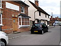
Former Kings Head, Stebbing
A grade II listed building, 16th century or earlier. A 2010 report describes it as being a pub 'until recently'. The two houses beyond are also grade II listed.
Image: © Robin Webster
Taken: 11 Jan 2015
0.09 miles
10
Stebbing, Essex
Just some of the many old houses that line the main street of Stebbing village.
Image: © Robert Edwards
Taken: 19 Sep 2005
0.10 miles