IMAGES TAKEN NEAR TO
Throws Corner, DUNMOW, CM6 3AF
Introduction
This page details the photographs taken nearby to Throws Corner, CM6 3AF by members of the Geograph project.
The Geograph project started in 2005 with the aim of publishing, organising and preserving representative images for every square kilometre of Great Britain, Ireland and the Isle of Man.

There are currently over 7.5m images from over14,400 individuals and you can help contribute to the project by visiting https://www.geograph.org.uk
Image Map
Images are licensed for reuse under creativecommons.org/licenses/by-sa/2.0
Notes
- Clicking on the map will re-center to the selected point.
- The higher the marker number, the further away the image location is from the centre of the postcode.
Image Listing (6 Images Found)
Images are licensed for reuse under creativecommons.org/licenses/by-sa/2.0
Image
Details
Distance
1
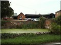
Throws Farm, near Little Dunmow, Essex
The 1940 O/S map shows the farm spelt as Throes.
Image: © Robert Edwards
Taken: 13 Sep 2006
0.04 miles
2
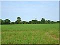
A field of beans
Between the new and old A120, the latter, the ancient Stane Street, now B1256.
Image: © Robin Webster
Taken: 7 Jun 2016
0.15 miles
3
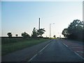
The B1256 Braintree Road, Throws
Station Road can be seen on the left ahead.
Image: © David Howard
Taken: 6 Jun 2013
0.18 miles
4
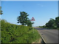
Junction on B1256
The turn for Little Dunmow.
Image: © Julian P Guffogg
Taken: 8 May 2015
0.20 miles
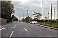
5
Station Road, Little Dunmow
Looking towards the bridge over the A120
Image: © David Howard
Taken: 6 Jun 2013
0.20 miles
6
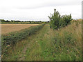
Bridleway to Clay Lane, Little Dunmow
Close to the bridge which carries the road to Little Dunmow over the A120, this path runs alongside recently harvested arable land.
Image: © Roger Jones
Taken: 1 Sep 2013
0.22 miles