IMAGES TAKEN NEAR TO
Broxted Road, DUNMOW, CM6 2HN
Introduction
This page details the photographs taken nearby to Broxted Road, CM6 2HN by members of the Geograph project.
The Geograph project started in 2005 with the aim of publishing, organising and preserving representative images for every square kilometre of Great Britain, Ireland and the Isle of Man.

There are currently over 7.5m images from over14,400 individuals and you can help contribute to the project by visiting https://www.geograph.org.uk
Image Map
Images are licensed for reuse under creativecommons.org/licenses/by-sa/2.0
Notes
- Clicking on the map will re-center to the selected point.
- The higher the marker number, the further away the image location is from the centre of the postcode.
Image Listing (5 Images Found)
Images are licensed for reuse under creativecommons.org/licenses/by-sa/2.0
Image
Details
Distance
1
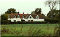
Old house, west of Great Easton, Essex
This house is known as Furrows.
Image: © Robert Edwards
Taken: 23 Oct 2006
0.04 miles
3
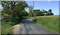
Broxted Road, Great Easton
The sign indicates the footpath to Tilty.
Image: © David Kemp
Taken: 23 May 2020
0.16 miles
4
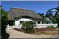
Foxholes, Broxted Road, Great Easton
This is an C18 Grade II Listed Building referred to on the OS Map.
Image: © David Kemp
Taken: 23 May 2020
0.21 miles
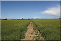
5
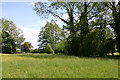
Footpath from Broxted Road to Brown's End Road, Great Easton
The line of trees marks the course of an un-named tributary of the River Chelmer crossed by the footpath.
Image: © David Kemp
Taken: 23 May 2020
0.22 miles