IMAGES TAKEN NEAR TO
Stortford Road, DUNMOW, CM6 1WY
Introduction
This page details the photographs taken nearby to Stortford Road, CM6 1WY by members of the Geograph project.
The Geograph project started in 2005 with the aim of publishing, organising and preserving representative images for every square kilometre of Great Britain, Ireland and the Isle of Man.

There are currently over 7.5m images from over14,400 individuals and you can help contribute to the project by visiting https://www.geograph.org.uk
Image Map
Images are licensed for reuse under creativecommons.org/licenses/by-sa/2.0
Notes
- Clicking on the map will re-center to the selected point.
- The higher the marker number, the further away the image location is from the centre of the postcode.
Image Listing (15 Images Found)
Images are licensed for reuse under creativecommons.org/licenses/by-sa/2.0
Image
Details
Distance
1
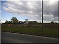
Dunmow Fencing Supplies on Stortford Road
Image: © David Howard
Taken: 18 Apr 2017
0.03 miles
2
The entrance to High Wood, Great Dunmow
Image: © David Howard
Taken: 19 Nov 2017
0.08 miles
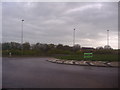
4
Roundabout on Stortford Road, Dunmow
The exit is for the A120 eastbound
Image: © David Howard
Taken: 18 Apr 2017
0.08 miles
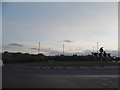
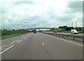
5
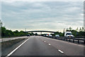
A120 towards Great Dunmow
Slip road from junction of B1256 is on the left.
Image: © Julian P Guffogg
Taken: 8 May 2015
0.10 miles
6
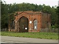
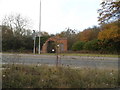
Old gatehouse at High Wood, Gt. Dunmow, Essex
This ruined brick gatehouse stands at the entrance to High Wood. Information about it is not easy to find.
Image: © Robert Edwards
Taken: 15 Sep 2006
0.12 miles
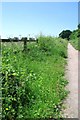
7

Flitch Way, near Great Dunmow
Much of the Flitch Way follows the course of a dismantled railway line. West of Great Dunmow, however, a busy by-pass road has been built which cuts across the former railway. The Flitch Way therefore diverts off the former railway in order to cross the by-pass. It then runs alongside the railway alignment rather than along it for a short distance, before returning to the railway alignment at Easton Lodge Halt.
Image: © Malc McDonald
Taken: 29 Oct 2022
0.14 miles
8
Route 16
Route 16 on the National Cycle Network and the Flitch Way Country Park https://www.essexhighways.org/Uploads/Files/flitchway.pdf
Image: © Glyn Baker
Taken: 29 Jun 2019
0.15 miles
9
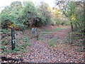
Flitch Way, near Great Dunmow
A gate on the Flitch Way near the town of Great Dunmow. The gate prevents motor vehicles from using the path.
Image: © Malc McDonald
Taken: 29 Oct 2022
0.17 miles
10
A120 overbridge carries Buttleys Lane
Image: © Stuart Logan
Taken: 23 Jun 2013
0.23 miles