IMAGES TAKEN NEAR TO
Chelmsford Road, DUNMOW, CM6 1RQ
Introduction
This page details the photographs taken nearby to Chelmsford Road, CM6 1RQ by members of the Geograph project.
The Geograph project started in 2005 with the aim of publishing, organising and preserving representative images for every square kilometre of Great Britain, Ireland and the Isle of Man.

There are currently over 7.5m images from over14,400 individuals and you can help contribute to the project by visiting https://www.geograph.org.uk
Image Map
Images are licensed for reuse under creativecommons.org/licenses/by-sa/2.0
Notes
- Clicking on the map will re-center to the selected point.
- The higher the marker number, the further away the image location is from the centre of the postcode.
Image Listing (5 Images Found)
Images are licensed for reuse under creativecommons.org/licenses/by-sa/2.0
Image
Details
Distance
1
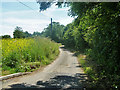
Lane to Colville Hall
A dead-end also serving one or two other houses.
Image: © Robin Webster
Taken: 30 Jun 2013
0.15 miles
2
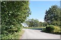
Lane beside the new entrance to Colville Hall
Colville Hall is now a wedding venue and has a new entrance from the lane, just south of the junction with the A1060. The junction can be seen ahead here.
Image: © Trevor Harris
Taken: 15 Sep 2023
0.19 miles
4
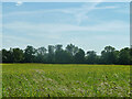
Lane from Colville Hall meets A1060 Chelmsford Road
Near left is a newly made (2013) private drive entrance to Colville Hall, the old lane serving just Colville Hall Cottages normally.
Image: © Robin Webster
Taken: 30 Jun 2013
0.20 miles
5
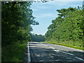
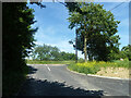
A1060 Chelmsford Road
Towards Hatfield Heath and Bishop's Stortford.
Image: © Robin Webster
Taken: 30 Jun 2013
0.21 miles