IMAGES TAKEN NEAR TO
Silver Lane, ONGAR, CM5 0QR
Introduction
This page details the photographs taken nearby to Silver Lane, CM5 0QR by members of the Geograph project.
The Geograph project started in 2005 with the aim of publishing, organising and preserving representative images for every square kilometre of Great Britain, Ireland and the Isle of Man.

There are currently over 7.5m images from over14,400 individuals and you can help contribute to the project by visiting https://www.geograph.org.uk
Image Map
Images are licensed for reuse under creativecommons.org/licenses/by-sa/2.0
Notes
- Clicking on the map will re-center to the selected point.
- The higher the marker number, the further away the image location is from the centre of the postcode.
Image Listing (8 Images Found)
Images are licensed for reuse under creativecommons.org/licenses/by-sa/2.0
Image
Details
Distance
1
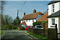
Cottage, Silver Lane
Within the parish of Willingale, which has scattered settlements in common with most parishes in this rural area.
Image: © Robin Webster
Taken: 25 Mar 2012
0.06 miles
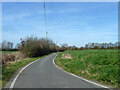
2
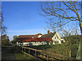
Clapsgate Farm, Wall's End, Essex
Looking west in Silver Street.
Image: © John Winfield
Taken: 14 Nov 2005
0.09 miles
5
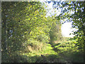
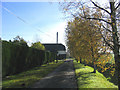
Bridleway, Stays Lane, near Willingale, Essex
This bridleway runs east from Wood Lane. Although it is clearly just a bridleway the OS map shows this as 'Stays Lane'.
Image: © John Winfield
Taken: 14 Nov 2005
0.14 miles
7
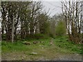
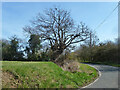
Public bridleway known as Stays Lane
It later joins another bridleway known as Shellow Lane.
Image: © Robert Edwards
Taken: 18 Apr 2008
0.18 miles
8
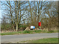
Postbox, Walls Green
At the start of a dead-end road going through Walls Green to Quires Green.
Image: © Robin Webster
Taken: 25 Mar 2012
0.22 miles