IMAGES TAKEN NEAR TO
Blackmore Mead, INGATESTONE, CM4 0SP
Introduction
This page details the photographs taken nearby to Blackmore Mead, CM4 0SP by members of the Geograph project.
The Geograph project started in 2005 with the aim of publishing, organising and preserving representative images for every square kilometre of Great Britain, Ireland and the Isle of Man.

There are currently over 7.5m images from over14,400 individuals and you can help contribute to the project by visiting https://www.geograph.org.uk
Image Map
Images are licensed for reuse under creativecommons.org/licenses/by-sa/2.0
Notes
- Clicking on the map will re-center to the selected point.
- The higher the marker number, the further away the image location is from the centre of the postcode.
Image Listing (75 Images Found)
Images are licensed for reuse under creativecommons.org/licenses/by-sa/2.0
Image
Details
Distance
1
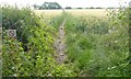
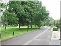
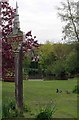
St Peter's Way from Blackmore
This public footpath across the field takes St Peter's Way east out of Blackmore. It is also on the route of the London Green Belt Way.
Image: © Sean Davis
Taken: 7 Jul 2007
0.06 miles
2
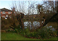
River Wid, Blackmore looking upstream
The Wid, a tributary of the Can which it joins at Writtle, expands into two ponds either side of The Green. Seen here is the one on the north side.
Image: © David Kemp
Taken: 9 Dec 2020
0.07 miles
3
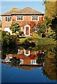
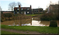
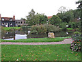
The Village Pond, Blackmore
A house reflected in the northern part of the village pond.
Image: © Trevor Harris
Taken: 2 Oct 2011
0.08 miles
4
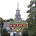
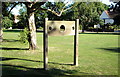
Blackmore Village Sign (Close Up)
The Blackmore village sign includes a motif of the late medieval wooden steeple of St Lawrence church http://www.geograph.org.uk/photo/2442394
Image: © Roger Jones
Taken: 12 Oct 2013
0.09 miles
5
Blacksmiths Alley, Blackmore, Essex
Bordering the pretty village green and some very fine houses off to the right, it doesn't fit my description of an "alley"
Image: © Derek Voller
Taken: 13 Jun 2012
0.09 miles
6
The Old Stocks on The Village Green at Blackmore
Image: © Sean Davis
Taken: 12 Jul 2005
0.09 miles
7
River Wid, Blackmore looking downstream
The Wid, a tributary of the Can which it joins at Writtle, expands into two ponds either side of The Green. Seen here is the one on the south side.
Image: © David Kemp
Taken: 9 Dec 2020
0.10 miles
8
Blackmore village green
Out of picture to the left is the large village pond over which is a small bridge carrying the road shown. The sign warns drivers of the many water birds in the viscinity.
Image: © Derek Voller
Taken: 13 Jun 2012
0.10 miles
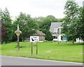
9
Blackmore Pond & Village Sign
A pity I was too late for the daffodils.
Image: © Glyn Baker
Taken: 8 May 2015
0.10 miles
10
Blackmore Village Pond
The south section of the pond, adjoining the village green.
Image: © Roger Jones
Taken: 12 Oct 2013
0.10 miles