IMAGES TAKEN NEAR TO
Beggar Hill, INGATESTONE, CM4 0PG
Introduction
This page details the photographs taken nearby to Beggar Hill, CM4 0PG by members of the Geograph project.
The Geograph project started in 2005 with the aim of publishing, organising and preserving representative images for every square kilometre of Great Britain, Ireland and the Isle of Man.

There are currently over 7.5m images from over14,400 individuals and you can help contribute to the project by visiting https://www.geograph.org.uk
Image Map
Images are licensed for reuse under creativecommons.org/licenses/by-sa/2.0
Notes
- Clicking on the map will re-center to the selected point.
- The higher the marker number, the further away the image location is from the centre of the postcode.
Image Listing (2 Images Found)
Images are licensed for reuse under creativecommons.org/licenses/by-sa/2.0
Image
Details
Distance
1
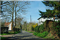
Beggar Hill, Fryerning
Several houses are scattered along this lane.
Image: © Robin Webster
Taken: 25 Mar 2012
0.13 miles
2
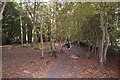
Mapletree Lane by College Wood
Mapletree Lane here runs between two strong (medieval?) boundary ditches and wood banks. These are unusually wide apart, leading me to think that this was perhaps a drove road. It is also very straight - on the line of a Roman road perhaps. The present path meanders between the wood banks through secondary woodland.
Image: © Trevor Harris
Taken: 2 Oct 2011
0.24 miles