IMAGES TAKEN NEAR TO
Willow Green, INGATESTONE, CM4 0DH
Introduction
This page details the photographs taken nearby to Willow Green, CM4 0DH by members of the Geograph project.
The Geograph project started in 2005 with the aim of publishing, organising and preserving representative images for every square kilometre of Great Britain, Ireland and the Isle of Man.

There are currently over 7.5m images from over14,400 individuals and you can help contribute to the project by visiting https://www.geograph.org.uk
Image Map
Images are licensed for reuse under creativecommons.org/licenses/by-sa/2.0
Notes
- Clicking on the map will re-center to the selected point.
- The higher the marker number, the further away the image location is from the centre of the postcode.
Image Listing (64 Images Found)
Images are licensed for reuse under creativecommons.org/licenses/by-sa/2.0
Image
Details
Distance
1
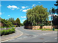
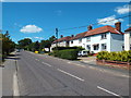
Willow Green, Ingatestone
Willow Green is a residential road in the village of Ingatestone in Essex.
Image: © Malc McDonald
Taken: 7 Jun 2015
0.07 miles
2
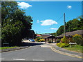
Wadham Close, Ingatestone
Wadham Close is a residential cul-de-sac in the village of Ingatestone.
Image: © Malc McDonald
Taken: 7 Jun 2015
0.09 miles
3
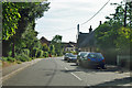
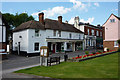
Fryerning Lane enters Ingatestone
Ingatestone was and is the principal village on the old Roman road between Brentwood and Chelmsford.
Image: © Robin Webster
Taken: 15 Sep 2011
0.10 miles
4
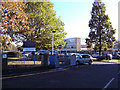
Anglo European School, Ingatestone, Essex
It is a self-governing,co-educational state school situated in Ingatestone, Essex. It is a school for boys and girls of all abilities, with 1,306 students aged 11 to 19. It was the first state school in Britain to offer the International Baccalaureate Diploma and the first to become a Language College.
Image: © Peter Stack
Taken: 20 Oct 2010
0.10 miles
5
Fryerning Lane, Ingatestone
Fryerning Lane in the village of Ingatestone, Essex.
Image: © Malc McDonald
Taken: 7 Jun 2015
0.14 miles
6
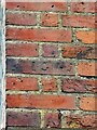
Parish boundary marker, inscribed brick - IG 1745
Approximately 4 metres high on the right flank wall of the Baker's House.
Milestone Society National ID: EX_INGA02pb
Image: © Paul Jones
Taken: 1 Nov 2020
0.15 miles
7
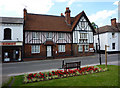
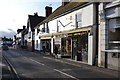
Ingatestone High Street
Opposite the church.
Image: © Andrew Hill
Taken: 16 Jun 2009
0.16 miles
8
Ingatestone High Street
Opposite the parish church.
Image: © Andrew Hill
Taken: 16 Jun 2009
0.16 miles
9
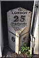
To London 23
Old cast iron milepost at Ingatestone, Essex. For overall view see http://www.geograph.org.uk/photo/4313008
Image: © Keith Evans
Taken: 11 Dec 2014
0.17 miles
10
Old Cast Iron Milepost
Old cast iron milepost to the right of Oaktree Gallery at Ingatestone, Essex. For close up view see http://www.geograph.org.uk/photo/4313005
Image: © Keith Evans
Taken: 11 Dec 2014
0.17 miles