IMAGES TAKEN NEAR TO
Abbey Fields, CHELMSFORD, CM3 8XB
Introduction
This page details the photographs taken nearby to Abbey Fields, CM3 8XB by members of the Geograph project.
The Geograph project started in 2005 with the aim of publishing, organising and preserving representative images for every square kilometre of Great Britain, Ireland and the Isle of Man.

There are currently over 7.5m images from over14,400 individuals and you can help contribute to the project by visiting https://www.geograph.org.uk
Image Map (Loading...)


Getting Data...Please wait
Leaflet Map data © OpenStreetMap
Images are licensed for reuse under creativecommons.org/licenses/by-sa/2.0
Notes
- Clicking on the map will re-center to the selected point.
- The higher the marker number, the further away the image location is from the centre of the postcode.
Image Listing (17 Images Found)
Images are licensed for reuse under creativecommons.org/licenses/by-sa/2.0
Image
Details
Distance
1
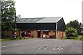
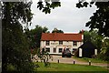
East Hanningfield Post Office
The left hand end of this building also houses the village hall. It is great for a village to have a post office and a village hall - even if the building, as here, strikes as slightly incongruous!
Image: © Trevor Harris
Taken: 9 Jun 2009
0.09 miles
2
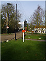
East Hanningfield village scene
Quiet and picturesque village
Image: © Julieanne Savage
Taken: 2 Feb 2008
0.09 miles
3
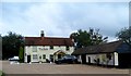
Former Three Horseshoes Pub
Now an Italian Restaurant. See http://www.geograph.org.uk/photo/1346990 for an earlier picture when it was an Asian restaurant and still called the Three Horseshoes.
Image: © Bikeboy
Taken: 13 Sep 2014
0.11 miles
4
Vita Bella, East Hanningfield
A 'ristorante italiano', formerly the Three Horse Shoes Inn.
Image: © Robin Webster
Taken: 11 Dec 2012
0.12 miles
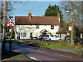
5
Three Horseshoes, East Hanningfield
The old public house is now called Hoyzen - a restaurant specialising in Asian sea-food.
Image: © Trevor Harris
Taken: 9 Jun 2009
0.12 miles
6
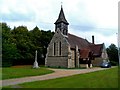
All Saints church, East Hanningfield
This church was built between 1884-5. The architect was Henry Stone. The church replaced a C13 on a nearby site which burnt down.
Image: © Bikeboy
Taken: 13 Sep 2014
0.14 miles
7
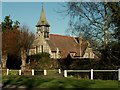
All Saints; the parish church of East Hanningfield
This Victorian church replaces a much earlier church that stood southwest of the village. That church is now a ruin.
Image: © Robert Edwards
Taken: 8 Feb 2008
0.14 miles
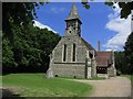
9
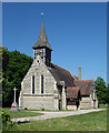
Church of All Saints, East Hanningfield
Grade II listed church completed in 1885 to a design by architect Henry Stone. Extensive description at this https://historicengland.org.uk/listing/the-list/list-entry/1408737.
Image: © Jim Osley
Taken: 25 May 2017
0.15 miles
10
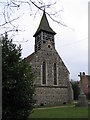
Church of All Saints
Parish Church in East Hanningfield
Image: © Angela Tuff
Taken: 14 Jan 2006
0.15 miles