IMAGES TAKEN NEAR TO
Crows Lane, CHELMSFORD, CM3 8RS
Introduction
This page details the photographs taken nearby to Crows Lane, CM3 8RS by members of the Geograph project.
The Geograph project started in 2005 with the aim of publishing, organising and preserving representative images for every square kilometre of Great Britain, Ireland and the Isle of Man.

There are currently over 7.5m images from over14,400 individuals and you can help contribute to the project by visiting https://www.geograph.org.uk
Image Map
Images are licensed for reuse under creativecommons.org/licenses/by-sa/2.0
Notes
- Clicking on the map will re-center to the selected point.
- The higher the marker number, the further away the image location is from the centre of the postcode.
Image Listing (8 Images Found)
Images are licensed for reuse under creativecommons.org/licenses/by-sa/2.0
Image
Details
Distance
1
Emberson Lodge
This is the footpath from Crows Lane to Cock Clarks at Emberson Lodge
Image: © Glyn Baker
Taken: 12 Nov 2006
0.03 miles
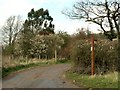
2
Bridleway/footpath junction near Seven Acre Farm
The finger post is looking rather the worse for wear (compared to it in the geograph by Robert Edwards from 2008).
Image: © Trevor Harris
Taken: 9 Jun 2009
0.03 miles
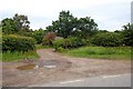
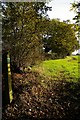
3
A footpath and bridleway meeting point
This is viewed from Crows Lane.
Image: © Robert Edwards
Taken: 7 Apr 2008
0.03 miles
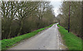
4
Bridleway from Crows Lane to Bicknacre
Brook Farm is behind the hedge to the left.
Image: © Robin Webster
Taken: 1 Jun 2014
0.05 miles
5
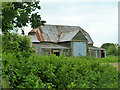
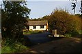
Barn, Brook Farm
There is no house here, but some smaller farm buildings in better repair are behind this one.
Image: © Robin Webster
Taken: 1 Jun 2014
0.10 miles
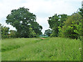
6
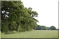
Field and hedgerow near Brook Farm
Taken from the bridleway to Bicknacre, with the delightfully named Squeaking-gate Wood in the background.
Image: © Trevor Harris
Taken: 9 Jun 2014
0.15 miles
8
Footpath to Charity Lane
This is a new footpath following the hedge line it is not marked on my 1:25,000 map. It links the footpath from Crows Lane to Cock Clarks with another from further down Crows Lane that leads to Cank Wood and the Charity Lane bridle path.
Image: © Glyn Baker
Taken: 12 Nov 2006
0.25 miles