IMAGES TAKEN NEAR TO
The Paddock, CHELMSFORD, CM3 8FF
Introduction
This page details the photographs taken nearby to The Paddock, CM3 8FF by members of the Geograph project.
The Geograph project started in 2005 with the aim of publishing, organising and preserving representative images for every square kilometre of Great Britain, Ireland and the Isle of Man.

There are currently over 7.5m images from over14,400 individuals and you can help contribute to the project by visiting https://www.geograph.org.uk
Image Map
Images are licensed for reuse under creativecommons.org/licenses/by-sa/2.0
Notes
- Clicking on the map will re-center to the selected point.
- The higher the marker number, the further away the image location is from the centre of the postcode.
Image Listing (14 Images Found)
Images are licensed for reuse under creativecommons.org/licenses/by-sa/2.0
Image
Details
Distance
1
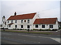
The Royal Tiger Thai Restaurant
This used to be the Plough and Sail Public House
Image: © Angela Tuff
Taken: 14 Jan 2006
0.03 miles
2
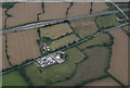
The Royal Tiger
The property with what looks like a marquee in the car park is Image
Image: © terry joyce
Taken: 18 Aug 2010
0.04 miles
3
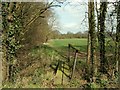
Footpath to East Hanningfield from Southend Road
Image: © Robert Edwards
Taken: 1 Apr 2008
0.11 miles
4
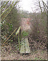
Overgrown footbridge, East Hanningfield
A public footpath runs over this bridge - clearly not often used as overgrown with bramble and other foliage. I did make it over but the path was not easily found on the field beyond.
Image: © Roger Jones
Taken: 1 Feb 2015
0.14 miles
5
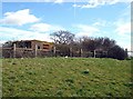
Type FW3/22 Pillbox
Part of the former GHQ Line, now perched atop the embankment of a lay-by on the "new" A130.
Image: © John Myers
Taken: 25 Mar 2008
0.16 miles
6
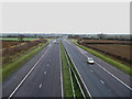
The A130
This is the A130 looking north towards Chelmsford. Taken from Canon Barns Bridge.
Image: © terry joyce
Taken: 2 Jan 2011
0.17 miles
7
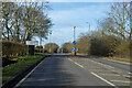
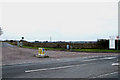
Main Road at turning for Hanningfield waterworks
Main Road no more, as this Southend - Chelmsford route has been paralleled by the A130 dual carriageway.
Image: © Robin Webster
Taken: 5 Feb 2023
0.20 miles
8
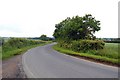
Double-bend on Pan Lane
Pan Lane runs from the old A130 near rettendon to East Hanningfield. From the second bend here a footpath leads back to the old A130.
Image: © Trevor Harris
Taken: 9 Jun 2009
0.21 miles
9
Access Road
This is the access road to Hanningfield water treatment works from the Southend Road (old A130).
Image: © terry joyce
Taken: 2 Jan 2011
0.21 miles
10
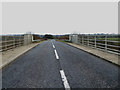
Canon Barns Bridge
This is the bridge that carries the access road to Hanningfield water treatment works over the A130.
Image: © terry joyce
Taken: 2 Jan 2011
0.22 miles