IMAGES TAKEN NEAR TO
Chalk Street, CHELMSFORD, CM3 8DD
Introduction
This page details the photographs taken nearby to Chalk Street, CM3 8DD by members of the Geograph project.
The Geograph project started in 2005 with the aim of publishing, organising and preserving representative images for every square kilometre of Great Britain, Ireland and the Isle of Man.

There are currently over 7.5m images from over14,400 individuals and you can help contribute to the project by visiting https://www.geograph.org.uk
Image Map (Loading...)


Getting Data...Please wait
Leaflet Map data © OpenStreetMap
Images are licensed for reuse under creativecommons.org/licenses/by-sa/2.0
Notes
- Clicking on the map will re-center to the selected point.
- The higher the marker number, the further away the image location is from the centre of the postcode.
Image Listing (7 Images Found)
Images are licensed for reuse under creativecommons.org/licenses/by-sa/2.0
Image
Details
Distance
1
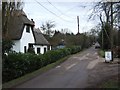
Cottage in Chalk Street.
This thatched cottage is in Chalk St in the hamlet of Coalhill near South Hanningfield.The photograph was taken looking southbound.
Image: © Glyn Baker
Taken: 18 Feb 2006
0.09 miles
2
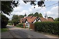
Former Chapel in Chalk Street
It is now a private house called "Cherry Chapel".
Image: © Trevor Harris
Taken: 6 Jun 2009
0.13 miles
3
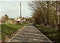
Warren Road, close to South Hanningfield
Image: © Robert Edwards
Taken: 1 Apr 2008
0.21 miles
4
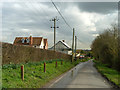
Warren Road
The scaffolded house is the original house here at Uplands Farm, the two houses to the left are new build.
Image: © Robin Webster
Taken: 4 Mar 2014
0.23 miles
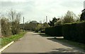
5
Warren Road, Rettendon
Rural road with horse paddocks on right and arable land on left, leading to scattered housing.
Image: © Roger Jones
Taken: 18 Apr 2015
0.23 miles
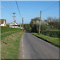
6
Looking south down Chalk Street
This is the view you see as you turn into Chalk Street from South Hanningfield Road.
Image: © Robert Edwards
Taken: 1 Apr 2008
0.24 miles
7
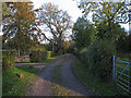
Bridleway to Chalk Street
This track, serving a few houses, is also a public footpath and a bridleway.
Image: © Roger Jones
Taken: 3 Nov 2012
0.25 miles