IMAGES TAKEN NEAR TO
The Withy Windle, CHELMSFORD, CM3 7BB
Introduction
This page details the photographs taken nearby to The Withy Windle, CM3 7BB by members of the Geograph project.
The Geograph project started in 2005 with the aim of publishing, organising and preserving representative images for every square kilometre of Great Britain, Ireland and the Isle of Man.

There are currently over 7.5m images from over14,400 individuals and you can help contribute to the project by visiting https://www.geograph.org.uk
Image Map
Images are licensed for reuse under creativecommons.org/licenses/by-sa/2.0
Notes
- Clicking on the map will re-center to the selected point.
- The higher the marker number, the further away the image location is from the centre of the postcode.
Image Listing (12 Images Found)
Images are licensed for reuse under creativecommons.org/licenses/by-sa/2.0
Image
Details
Distance
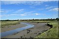
1
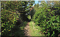
Fenn Creek Path
There are dwellings just behind the hedge see my thoughts at Image
Image: © Glyn Baker
Taken: 11 Aug 2013
0.09 miles
2
Up Split Creek?
A bifurcation in Fen Creek
Image: © Glyn Baker
Taken: 11 Aug 2013
0.13 miles
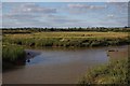
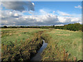
3
Creek Junction
Woodham Creek joins Fenn Creek, Woodham Fen Nature Reserve is to the north of this junction. (Also spelt Woodham Fenn).
The 20 acre reserve lies between and near the tidal limits of these two small creeks running south into the River Crouch. The southern part is saltmarsh and the northern rough grassland with a transitional zone between the two - of special interest because this natural transition is now very unusual in Essex. See Essex Wildlife Trust http://www.essexwt.org.uk/visitor_centres__nature_reserves/woodham_fen/ .
Image: © Roger Jones
Taken: 14 Oct 2012
0.13 miles
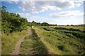
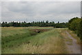
4
Footpath along Fenn Creek
Footpath running alongside Fenn Creek, leading to Woodham Fen Nature Reserve.
Image: © Roger Jones
Taken: 14 Oct 2012
0.14 miles
5
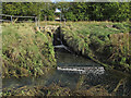
Small sluice and weir
Outlet from what looks like a water processing plant flowing into Fenn Creek.
Image: © Roger Jones
Taken: 14 Oct 2012
0.16 miles
6
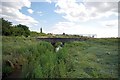
Bridge in Woodham Fen
The right bank of the creek is the boundary of Image nature reserve
Image: © Glyn Baker
Taken: 11 Aug 2013
0.17 miles
7
Woodham Fen Reserve
Image: © Glyn Baker
Taken: 11 Aug 2013
0.17 miles
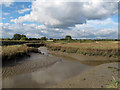
8
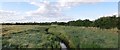
Fenn Creek
Seen from the bridge at Woodham Fen Nature Reserve. (Also spelt Woodham Fenn).
The 20 acre reserve lies between and near the tidal limits of two small creeks running south into the River Crouch. The southern part is saltmarsh and the northern rough grassland with a transitional zone between the two - of special interest because this natural transition is now very unusual in Essex. See Essex Wildlife Trust http://www.essexwt.org.uk/visitor_centres__nature_reserves/woodham_fen/ .
Image: © Roger Jones
Taken: 14 Oct 2012
0.22 miles
9
Woodham Fen
The foot bridge forms the entrance to the Essex Wildlife Trust reserve.
Image: © John Myers
Taken: 27 Jul 2010
0.22 miles