IMAGES TAKEN NEAR TO
Mallards, CHELMSFORD, CM3 6TN
Introduction
This page details the photographs taken nearby to Mallards, CM3 6TN by members of the Geograph project.
The Geograph project started in 2005 with the aim of publishing, organising and preserving representative images for every square kilometre of Great Britain, Ireland and the Isle of Man.

There are currently over 7.5m images from over14,400 individuals and you can help contribute to the project by visiting https://www.geograph.org.uk
Image Map (Loading...)


Getting Data...Please wait
Leaflet Map data © OpenStreetMap
Images are licensed for reuse under creativecommons.org/licenses/by-sa/2.0
Notes
- Clicking on the map will re-center to the selected point.
- The higher the marker number, the further away the image location is from the centre of the postcode.
Image Listing (2 Images Found)
Images are licensed for reuse under creativecommons.org/licenses/by-sa/2.0
Image
Details
Distance
1
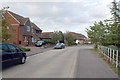
Drake Avenue, Mayland
Drake Avenue is one of several roads serving this residential area called after water-birds - Heron Way, Curlew Avenue, Tern Close etc. Fittingly, behind the fence on the left is a duck pond owned by the residents of Grebe Close.
Image: © Trevor Harris
Taken: 19 Jul 2009
0.10 miles
2
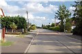
The Drive, Mayland
Looking along The Drive northwards towards its junction with Steeple Road.
Image: © Trevor Harris
Taken: 19 Jul 2009
0.20 miles