IMAGES TAKEN NEAR TO
Church Road, CHELMSFORD, CM3 6LU
Introduction
This page details the photographs taken nearby to Church Road, CM3 6LU by members of the Geograph project.
The Geograph project started in 2005 with the aim of publishing, organising and preserving representative images for every square kilometre of Great Britain, Ireland and the Isle of Man.

There are currently over 7.5m images from over14,400 individuals and you can help contribute to the project by visiting https://www.geograph.org.uk
Image Map
Images are licensed for reuse under creativecommons.org/licenses/by-sa/2.0
Notes
- Clicking on the map will re-center to the selected point.
- The higher the marker number, the further away the image location is from the centre of the postcode.
Image Listing (14 Images Found)
Images are licensed for reuse under creativecommons.org/licenses/by-sa/2.0
Image
Details
Distance
1
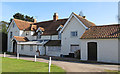
North Fambridge Hall
Listed building on Church Road: House, mainly c.1600, possibly of medieval origin, altered in C19.
List entry Number: 1110879 http://list.english-heritage.org.uk/resultsingle.aspx?uid=1110879
Image: © Roger Jones
Taken: 1 Apr 2012
0.03 miles
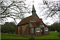
2
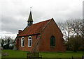
Holy Trinity, North Fambridge - south-east elevation
Most of the church dates from the mid-C18.
Image: © David Kemp
Taken: 19 Mar 2023
0.05 miles
4
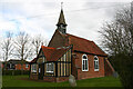
Holy Trinity, North Fambridge - south-west elevation
Most of the church dates from the mid-C18. As the background to the picture suggests, this once isolated area is today becoming increasingly urban in appearance.
Image: © David Kemp
Taken: 19 Mar 2023
0.05 miles
5
Holy Trinity, North Fambridge - north-west elevation
Most of the church dates from the mid-C18.
Image: © David Kemp
Taken: 19 Mar 2023
0.05 miles
6
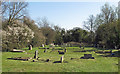
Holy Trinity Churchyard
A number of graves in the churchyard of Holy Trinity, North Fambridge.
Image: © Roger Jones
Taken: 1 Apr 2012
0.08 miles
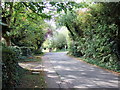
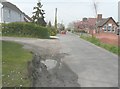
7
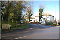
Junction of Ferry Road and Church Road
Looking from Ferry Road towards Church Road.
Image: © Trevor Harris
Taken: 30 Nov 2012
0.09 miles
8
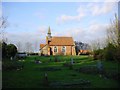
Holy Trinity North Fambridge
Holy Trinity nestles in the rural parish of North Fambridge, Essex, in the Dengie peninsula approximately 48 miles east of the centre of London. It is one of two parishes at Fambridge, South Fambridge being on the other side of the tidal River Crouch. Surrounded by farmland, North Fambridge is adjacent to the Essex Wildlife Trust site of Blue House Farm.
Image: © Joan Kent
Taken: 18 Dec 2004
0.10 miles
9
Looking north along Ferry Road
River Cottage, dated 1902, is the grey-painted house on the left, while across the road is the village hall that dates from 1875.
Image: © John Baker
Taken: 3 Apr 2014
0.19 miles
10
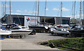
Fambridge Yacht Haven yard
For more info on Fambridge Yacht Haven see http://www.yachthavens.com/fambridge/
Was formerly known as West Wick Marina.
Image: © Roger Jones
Taken: 1 Apr 2012
0.19 miles