IMAGES TAKEN NEAR TO
King Edwards Road, CHELMSFORD, CM3 5PQ
Introduction
This page details the photographs taken nearby to King Edwards Road, CM3 5PQ by members of the Geograph project.
The Geograph project started in 2005 with the aim of publishing, organising and preserving representative images for every square kilometre of Great Britain, Ireland and the Isle of Man.

There are currently over 7.5m images from over14,400 individuals and you can help contribute to the project by visiting https://www.geograph.org.uk
Image Map (Loading...)


Getting Data...Please wait
Leaflet Map data © OpenStreetMap
Images are licensed for reuse under creativecommons.org/licenses/by-sa/2.0
Notes
- Clicking on the map will re-center to the selected point.
- The higher the marker number, the further away the image location is from the centre of the postcode.
Image Listing (20 Images Found)
Images are licensed for reuse under creativecommons.org/licenses/by-sa/2.0
Image
Details
Distance
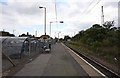
2
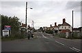
Road past South Woodham Ferrers Station
Image: © John Salmon
Taken: 11 Sep 2008
0.16 miles
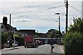
4
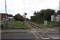
South Woodham Ferrers Station - Level crossing
Image: © John Salmon
Taken: 11 Sep 2008
0.16 miles
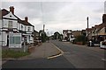
5
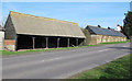
Hambert's Farm barns
Older farm buildings on Burnham Road (B1012), most likely C19 or earlier; when these barns were built the township of "South Woodham Ferrers" had not yet been formed.
Image: © Roger Jones
Taken: 25 Mar 2012
0.17 miles
6
South Woodham Ferrers Station - Level crossing
Image: © John Salmon
Taken: 11 Sep 2008
0.17 miles
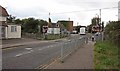
7
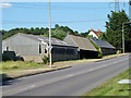
Buildings, Hamberts Farm
Three ages of farm building here. In the centre is a six bay wagon shed with a replacement roof, but with old timber framing. It opens towards the road, which now has been raised above the floor level, making use for vehicles impractical. The far brick building, actually L-shaped with equal legs, has raised roof vents and small openings in the outer walls. What was this used for?
Image: © Robin Webster
Taken: 21 Jun 2014
0.18 miles
8
South Woodham Ferrers Station - Level crossing
Image: © John Salmon
Taken: 11 Sep 2008
0.18 miles
10
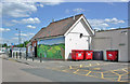
South Woodham Ferrers station, 2015: decorated exterior
View eastward, towards Burnham-on-Crouch and Southminster. Someone has painted a nice mural, probably during the recent (May 2007) renovation, when the name was changed from plain 'Woodham Ferrers'. (See Image and Image).
Image: © Ben Brooksbank
Taken: 15 Jun 2015
0.19 miles