IMAGES TAKEN NEAR TO
Gay Bowers Road, CM3 4FS
Introduction
This page details the photographs taken nearby to Gay Bowers Road, CM3 4FS by members of the Geograph project.
The Geograph project started in 2005 with the aim of publishing, organising and preserving representative images for every square kilometre of Great Britain, Ireland and the Isle of Man.

There are currently over 7.5m images from over14,400 individuals and you can help contribute to the project by visiting https://www.geograph.org.uk
Image Map
Images are licensed for reuse under creativecommons.org/licenses/by-sa/2.0
Notes
- Clicking on the map will re-center to the selected point.
- The higher the marker number, the further away the image location is from the centre of the postcode.
Image Listing (17 Images Found)
Images are licensed for reuse under creativecommons.org/licenses/by-sa/2.0
Image
Details
Distance
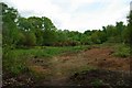
1
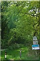
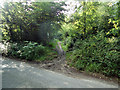
The Backwarden
This is a pedestrian entrance to Backwarden Nature Reserve found in the south-east corner of Image it is owned by the National Trust and managed by The Essex Wildlife Trust http://www.essexwt.org.uk/visitor_centres__nature_reserves/danbury_ridge/ . It has a great diversity of heathland, woodland and wetland habitat. It is rich in wildlife from dormice to nightingales. Botany fans can hunt for water-dropwort and lesser skullcap among many others.
Image: © Glyn Baker
Taken: 2 May 2009
0.03 miles
2
Gay Bowers Road at the junction of Bicknacre Road
Image: © David Howard
Taken: 4 Jul 2020
0.03 miles
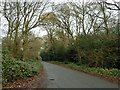
3
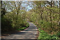
Gay Bowers Road
The road forms the southern boundary of Danbury Common (which is to the right here); the southernmost area of the common is wooded.
Image: © Trevor Harris
Taken: 20 Apr 2015
0.07 miles
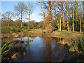
4
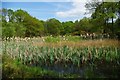
Backwarden Pond
A pond with bursting reed mace in Image Nature Reserve.
The Backwarden is owned by the National Trust and managed by Essex Wildlife Trust http://www.essexwt.org.uk/visitor_centres__nature_reserves/danbury_ridge/
Image: © Glyn Baker
Taken: 2 May 2009
0.13 miles
5
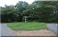
Danbury Common footpath
The entrance to Danbury Common from Gay Bowers road.
Image: © Roger Jones
Taken: 19 Jun 2011
0.13 miles
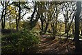
6
Gay Bowers Road
Passing through the southern margin of Danbury Common.
Image: © Robin Webster
Taken: 8 Dec 2012
0.14 miles
8
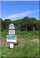
Backwarden Nature Reserve, Danbury Common
National Trust nature reserve on west side of Danbury Common
Image: © John Winfield
Taken: 28 Jun 2006
0.16 miles
9
Backwarden Scene
This shot of Image Nature Reserve clear shows the poor sandy soil that saved this land from disappearing under the plough. The heathland habitat can only be maintained by active management, or else scrub and finally woodland will take over. The Backwarden is owned by the National Trust and managed by Essex Wildlife Trusthttp://www.essexwt.org.uk/visitor_centres__nature_reserves/danbury_ridge/
Image: © Glyn Baker
Taken: 2 May 2009
0.17 miles
10
Temporary pond on Danbury Common
The combination of a recent thaw and waterlogged land has resulted in this temporary pond.
Danbury Common is a National Trust site see http://www.webcitation.org/6DzoBOzDt
Image: © Roger Jones
Taken: 27 Jan 2013
0.17 miles