IMAGES TAKEN NEAR TO
Margaret Woods Road, CHELMSFORD, CM3 1DZ
Introduction
This page details the photographs taken nearby to Margaret Woods Road, CM3 1DZ by members of the Geograph project.
The Geograph project started in 2005 with the aim of publishing, organising and preserving representative images for every square kilometre of Great Britain, Ireland and the Isle of Man.

There are currently over 7.5m images from over14,400 individuals and you can help contribute to the project by visiting https://www.geograph.org.uk
Image Map
Images are licensed for reuse under creativecommons.org/licenses/by-sa/2.0
Notes
- Clicking on the map will re-center to the selected point.
- The higher the marker number, the further away the image location is from the centre of the postcode.
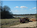
Image Listing (3 Images Found)
Images are licensed for reuse under creativecommons.org/licenses/by-sa/2.0
Image
Details
Distance
3
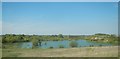
Flooded Gravel Pit
Known by the local angling club as 'Tufnell Mere', it contains a large head of carp as well as other fish. The water level of this pit has fluctuated greatly over the years, and is currently much higher than normal, as can be seen by the semi-submerged willow trees at the far end of the pit.
Image: © Paul Franks
Taken: 3 May 2013
0.25 miles