IMAGES TAKEN NEAR TO
Main Road, CHELMSFORD, CM3 1BL
Introduction
This page details the photographs taken nearby to Main Road, CM3 1BL by members of the Geograph project.
The Geograph project started in 2005 with the aim of publishing, organising and preserving representative images for every square kilometre of Great Britain, Ireland and the Isle of Man.

There are currently over 7.5m images from over14,400 individuals and you can help contribute to the project by visiting https://www.geograph.org.uk
Image Map
Images are licensed for reuse under creativecommons.org/licenses/by-sa/2.0
Notes
- Clicking on the map will re-center to the selected point.
- The higher the marker number, the further away the image location is from the centre of the postcode.
Image Listing (3 Images Found)
Images are licensed for reuse under creativecommons.org/licenses/by-sa/2.0
Image
Details
Distance
1
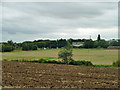
View across the Chelmer valley
The river is at the foot of the ploughed field. The cluster of street lights are at the roundabout where the Great Waltham bypass section of the B1008 (formerly A130) starts.
Image: © Robin Webster
Taken: 8 Sep 2011
0.07 miles
2
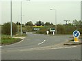
Part of the A130, Great Waltham by-pass
Image: © Robert Edwards
Taken: 25 Apr 2008
0.10 miles
3
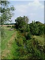
Chelmer from the A130
This is a photo of the River Chelmer taken from the A130 Bridge looking upstream. The river is not much more than a brook at the moment due to the dry weather
Image: © Glyn Baker
Taken: 3 Sep 2005
0.22 miles