IMAGES TAKEN NEAR TO
Bruce Grove, CHELMSFORD, CM2 9AY
Introduction
This page details the photographs taken nearby to Bruce Grove, CM2 9AY by members of the Geograph project.
The Geograph project started in 2005 with the aim of publishing, organising and preserving representative images for every square kilometre of Great Britain, Ireland and the Isle of Man.

There are currently over 7.5m images from over14,400 individuals and you can help contribute to the project by visiting https://www.geograph.org.uk
Image Map (Loading...)


Getting Data...Please wait
Leaflet Map data © OpenStreetMap
Images are licensed for reuse under creativecommons.org/licenses/by-sa/2.0
Notes
- Clicking on the map will re-center to the selected point.
- The higher the marker number, the further away the image location is from the centre of the postcode.
Image Listing (25 Images Found)
Images are licensed for reuse under creativecommons.org/licenses/by-sa/2.0
Image
Details
Distance
1
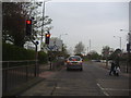
Princes Road approaching the Miami roundabout
The Miami hotel can just be seen on the left
Image: © David Howard
Taken: 2 May 2012
0.13 miles
2
Wood Street at the junction of Widford Grove
Image: © David Howard
Taken: 23 Feb 2019
0.13 miles
4
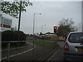
Traffic lights at the Miami roundabout, Chelmsford
Image: © David Howard
Taken: 2 May 2012
0.14 miles
5
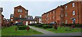
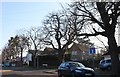
Chelmsford: former St John's Hospital, now redeveloped as residential properties
St John's Hospital, the former Chelmsford Workhouse, closed in 2010 and is now redeveloped for residential use. The streets are named after people linked to the history of the hospital.
See https://en.wikipedia.org/wiki/St_John%27s_Hospital,_Chelmsford for more detail.
Image: © Christopher Hilton
Taken: 28 Mar 2023
0.14 miles
6
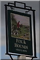
Sign for the Fox & Hounds, Chelmsford
See Image] for context.
Image: © JThomas
Taken: 11 May 2019
0.14 miles
7
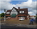
The Fox & Hounds, Chelmsford
On Wood Street.
Image: © JThomas
Taken: 11 May 2019
0.15 miles
8
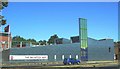
The Salvation Army Hall and Community Centre
This recently erected Worship Hall is of a modern design. The suite of buildings has been the recipient of several architectural awards. It has managed to achieve a relatively quiet atmosphere despite being adjacent to a busy dual carriageway.
Image: © Ken Brown
Taken: 3 Jun 2011
0.15 miles
9
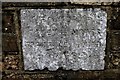
Old Boundary Marker by the A1114, Princes Road, Chelmsford
Estate Boundary Marker by the A1114, in parish of Chelmsford (Chelmsford District), Princes Road opposite Tesco, on a rear brick garden wall of the Chelmsford & Essex Regiment Museum.
Surveyed
Milestone Society National ID: EX_CHEL01em
Image: © Milestone Society
Taken: Unknown
0.15 miles
10
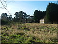
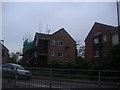
Derelict Buildings, St John's Hospital
The hospital site, which includes the former Chelmsford Union Workhouse, is awaiting redevelopment.
Image: © Paul Franks
Taken: 8 Feb 2013
0.15 miles