IMAGES TAKEN NEAR TO
The Common, CHELMSFORD, CM2 8PL
Introduction
This page details the photographs taken nearby to The Common, CM2 8PL by members of the Geograph project.
The Geograph project started in 2005 with the aim of publishing, organising and preserving representative images for every square kilometre of Great Britain, Ireland and the Isle of Man.

There are currently over 7.5m images from over14,400 individuals and you can help contribute to the project by visiting https://www.geograph.org.uk
Image Map (18 Images)


Getting Data...Please wait
Leaflet Map data © OpenStreetMap
Images are licensed for reuse under creativecommons.org/licenses/by-sa/2.0
Notes
- Clicking on the map will re-center to the selected point.
- The higher the marker number, the further away the image location is from the centre of the postcode.
Image Listing (18 Images Found)
Images are licensed for reuse under creativecommons.org/licenses/by-sa/2.0
Image
Details
Distance
1
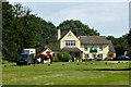
Horse and Groom and horse
A pleasant setting on Galleywood Common.
Image: © Robin Webster
Taken: 22 Jul 2012
0.01 miles
2
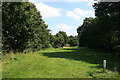
Galleywood Racecourse
Part of the disused racecourse. Horse racing took place here between 1759 and 1935.
Image: © Paul Franks
Taken: 11 Aug 2012
0.07 miles
4
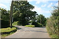
The Junction of Goat Hall Lane and Horse and Groom Lane
Horse and Groom Lane, on the left, leads to the Horse and Groom Pub.
Image: © Paul Franks
Taken: 11 Aug 2012
0.14 miles

6
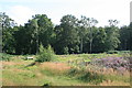
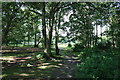
Galleywood Common
Heather and silver birches on Galleywood Common.
Image: © Paul Franks
Taken: 11 Aug 2012
0.14 miles
7
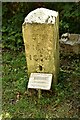
Ecclesiastical Parish boundary marker
Ecclesiastical Parish Boundary Marker in the churchyard of St Michael and All Angels' church. Galleywood parish. Inscribed G C / St M C C / 1874 (Galleywood Common St Michael Consolidated Chapelry). Originally sited in 1874 at Tile Kiln Farm, one of ten marking the boundary of Galleywood Common ecclesiastical parish. Found in Oaklands Park and moved to the church in 2004. Reference https://www.thegazette.co.uk/London/issue/24142/page/4766.
Milestone Society National ID: EX_GALLEY01pb
Image: © M Bardell
Taken: 12 Aug 2021
0.17 miles
8
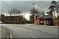
The B1007 at Galleywood
The small road off to the right is Goat Hill Lane.
Image: © Robert Edwards
Taken: 31 Mar 2008
0.17 miles
9
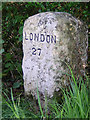
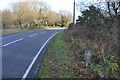
Old Milestone, Margaretting Road, Galleywood
The milestone is located 100m east of the car park entrance for Galleywood Common, under the hedge on the south side of road. Parish of Galleywood (Chelmsford District). Carved stone post, erected by an unknown authority in the 19th century.
Inscription reads:-
LONDON
27
Milestone Society National ID: EX_MGMN27
Image: © JV Nicholls
Taken: 25 Feb 2011
0.18 miles
10
Old Milestone
Old milestone near to Galleywood, Essex for close up view see http://www.geograph.org.uk/photo/4312929
Image: © Keith Evans
Taken: 11 Dec 2014
0.18 miles