IMAGES TAKEN NEAR TO
Mayes Lane, CHELMSFORD, CM2 7RW
Introduction
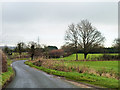
This page details the photographs taken nearby to Mayes Lane, CM2 7RW by members of the Geograph project.
The Geograph project started in 2005 with the aim of publishing, organising and preserving representative images for every square kilometre of Great Britain, Ireland and the Isle of Man.

There are currently over 7.5m images from over14,400 individuals and you can help contribute to the project by visiting https://www.geograph.org.uk
Image Map (Loading...)


Getting Data...Please wait
Leaflet Map data © OpenStreetMap
Images are licensed for reuse under creativecommons.org/licenses/by-sa/2.0
Notes
- Clicking on the map will re-center to the selected point.
- The higher the marker number, the further away the image location is from the centre of the postcode.
Image Listing (5 Images Found)
Images are licensed for reuse under creativecommons.org/licenses/by-sa/2.0
Image
Details
Distance
1
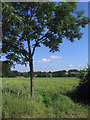
Tree and Field
Not an expert on trees but think this is a mountain ash, which if correct seems an odd tree to be on a field boundary.
Image: © John Winfield
Taken: 28 Jun 2006
0.08 miles
4
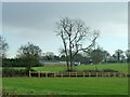
New looking but incomplete post and rail fence
Strangely, views some time later show that this fence has gone, and a mesh and wire fence erected.
Image: © Robin Webster
Taken: 8 Dec 2012
0.23 miles
5
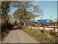
Sporhams Lane
This lane is so plated, and serves Sporhams Farm, yet the OS map calls it Sporehams Lane.
Image: © Robin Webster
Taken: 8 Dec 2012
0.25 miles