IMAGES TAKEN NEAR TO
Parkway, CHELMSFORD, CM2 7PX
Introduction
This page details the photographs taken nearby to Parkway, CM2 7PX by members of the Geograph project.
The Geograph project started in 2005 with the aim of publishing, organising and preserving representative images for every square kilometre of Great Britain, Ireland and the Isle of Man.

There are currently over 7.5m images from over14,400 individuals and you can help contribute to the project by visiting https://www.geograph.org.uk
Image Map
Images are licensed for reuse under creativecommons.org/licenses/by-sa/2.0
Notes
- Clicking on the map will re-center to the selected point.
- The higher the marker number, the further away the image location is from the centre of the postcode.
Image Listing (65 Images Found)
Images are licensed for reuse under creativecommons.org/licenses/by-sa/2.0
Image
Details
Distance
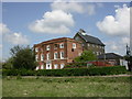
1
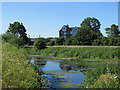
Chelmsford, Moulsham Mill
Former watermill on the River Chelmer, dating from 1819; now a craft and business centre. As seen from the neighbouring watermeadows. http://www.moulshammill.co.uk/page/history
Image: © Mike Faherty
Taken: 15 May 2010
0.01 miles
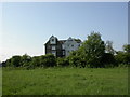
2
Chelmsford, mill house
Next to Image; C18, listed by English Heritage. http://www.imagesofengland.org.uk/Details/Default.aspx?id=352563&mode=adv
Image: © Mike Faherty
Taken: 15 May 2010
0.02 miles
3
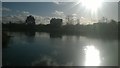
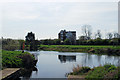
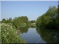
View down the River Chelmer towards Moulsham Mill
Image: © Christopher Hilton
Taken: 19 Jan 2018
0.03 miles
4
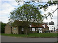
Chelmsford, country stores
Marriages Country Stores, off Parkway, next to Image Run by W&H Marriage & Sons Ltd, animal feed suppliers and former owners of Moulsham Mill. http://www.marriagefeeds.co.uk/
Image: © Mike Faherty
Taken: 15 May 2010
0.04 miles
5
Chelmsford: towards Moulsham Mill
The former water mill dates from 1819. For an April 2009 view across the River Chelmer from this spot, see Image
Image: © John Sutton
Taken: 22 Jun 2018
0.04 miles
7
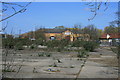
Former Jewsons Site
The site was at one time scheduled for redevelopment as a supermarket.
Image: © Paul Franks
Taken: 1 Apr 2012
0.06 miles
8
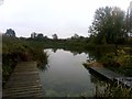
River Chelmer below the weir, Chelmsford
The landing stages on either side of the little inlet in the foreground allow people heading for the slipway around the weir to climb out. The slipway is behind the camera.
In the distance on the other side of the river, Moulsham Mill.
Image: © Christopher Hilton
Taken: 15 Oct 2018
0.07 miles
9
Chelmsford, River Chelmer
Looking upstream from the riverside walk.
Image: © Mike Faherty
Taken: 15 May 2010
0.08 miles
10
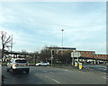
A138 Chelmer Road, Chelmsford
At the junction with the A130 Essex Yeomanny Road
Image: © Geographer
Taken: 14 Feb 2016
0.08 miles