IMAGES TAKEN NEAR TO
Cecil Close, BISHOP'S STORTFORD, CM23 5RD
Introduction
This page details the photographs taken nearby to Cecil Close, CM23 5RD by members of the Geograph project.
The Geograph project started in 2005 with the aim of publishing, organising and preserving representative images for every square kilometre of Great Britain, Ireland and the Isle of Man.

There are currently over 7.5m images from over14,400 individuals and you can help contribute to the project by visiting https://www.geograph.org.uk
Image Map (Loading...)


Getting Data...Please wait
Leaflet Map data © OpenStreetMap
Images are licensed for reuse under creativecommons.org/licenses/by-sa/2.0
Notes
- Clicking on the map will re-center to the selected point.
- The higher the marker number, the further away the image location is from the centre of the postcode.
Image Listing (7 Images Found)
Images are licensed for reuse under creativecommons.org/licenses/by-sa/2.0
Image
Details
Distance
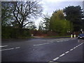
2
Roundabout
Junction of A1250 with Parsonage Lane, hidden start to footpaths nearby
Image: © John Smith
Taken: 8 Sep 2006
0.14 miles
3
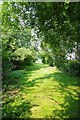
A Birchwood Bridleway
This bridleway runs across the Birchwood High School sports field
Image: © Glyn Baker
Taken: 5 Jul 2013
0.16 miles
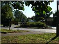
4
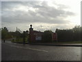
The entrance to Bishop's Stortford golf club
Image: © David Howard
Taken: 25 Apr 2012
0.16 miles
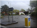
5
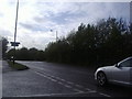
Dunmow Road, Bishop's Stortford
By the entrance to the golf club
Image: © David Howard
Taken: 25 Apr 2012
0.17 miles
6
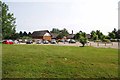
Bishop's Stortford Golf Club
This club boasts a 100 year old par 71 course http://www.bsgc.co.uk/
Image: © Glyn Baker
Taken: 5 Jul 2013
0.18 miles