IMAGES TAKEN NEAR TO
Vardon Drive, CM23 5FT
Introduction
This page details the photographs taken nearby to Vardon Drive, CM23 5FT by members of the Geograph project.
The Geograph project started in 2005 with the aim of publishing, organising and preserving representative images for every square kilometre of Great Britain, Ireland and the Isle of Man.

There are currently over 7.5m images from over14,400 individuals and you can help contribute to the project by visiting https://www.geograph.org.uk
Image Map
Images are licensed for reuse under creativecommons.org/licenses/by-sa/2.0
Notes
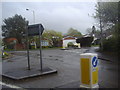
- Clicking on the map will re-center to the selected point.
- The higher the marker number, the further away the image location is from the centre of the postcode.
Image Listing (3 Images Found)
Images are licensed for reuse under creativecommons.org/licenses/by-sa/2.0
Image
Details
Distance
1
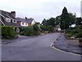
Haycroft
A residential cul-de-sac off Haymeads Lane.
Image: © Thomas Nugent
Taken: 5 Sep 2008
0.18 miles
3
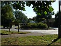
Roundabout
Junction of A1250 with Parsonage Lane, hidden start to footpaths nearby
Image: © John Smith
Taken: 8 Sep 2006
0.23 miles