IMAGES TAKEN NEAR TO
Ellis Drive, CM23 4RN
Introduction
This page details the photographs taken nearby to Ellis Drive, CM23 4RN by members of the Geograph project.
The Geograph project started in 2005 with the aim of publishing, organising and preserving representative images for every square kilometre of Great Britain, Ireland and the Isle of Man.

There are currently over 7.5m images from over14,400 individuals and you can help contribute to the project by visiting https://www.geograph.org.uk
Image Map
Images are licensed for reuse under creativecommons.org/licenses/by-sa/2.0
Notes
- Clicking on the map will re-center to the selected point.
- The higher the marker number, the further away the image location is from the centre of the postcode.
Image Listing (4 Images Found)
Images are licensed for reuse under creativecommons.org/licenses/by-sa/2.0
Image
Details
Distance
1
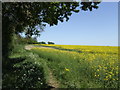
Arable field under threat?
This view along the Hertfordshire Way LDF looks to be in idyllic countryside. In fact the housing estates of Bishop's Stortford end only yards away across the road from here; see Image This field lies within the A1184 ring road and will probably be one of those green field sites that will be developed in order to provide more housing in the south-east of England.
Image: © Jonathan Billinger
Taken: 2 May 2007
0.08 miles
2
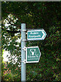
Hertfordshire Way signs
The long distance footpath, the Hertfordshire Way, joins a minor road on the outskirts of Bishop's Stortford near Thorley village
Image: © John Smith
Taken: 6 Sep 2006
0.13 miles
3
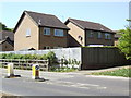
Housing in Bishop's Stortford
This scene is only a few yards from Image!
Image: © Jonathan Billinger
Taken: 2 May 2007
0.13 miles
4

Bishop's Stortford from the air
Most of the town can be seen in this view from a Birmingham bound flight from Prague.
Image: © Thomas Nugent
Taken: 11 Feb 2022
0.15 miles