IMAGES TAKEN NEAR TO
The Shearers, BISHOP'S STORTFORD, CM23 4AZ
Introduction
This page details the photographs taken nearby to The Shearers, CM23 4AZ by members of the Geograph project.
The Geograph project started in 2005 with the aim of publishing, organising and preserving representative images for every square kilometre of Great Britain, Ireland and the Isle of Man.

There are currently over 7.5m images from over14,400 individuals and you can help contribute to the project by visiting https://www.geograph.org.uk
Image Map
Images are licensed for reuse under creativecommons.org/licenses/by-sa/2.0
Notes
- Clicking on the map will re-center to the selected point.
- The higher the marker number, the further away the image location is from the centre of the postcode.
Image Listing (3 Images Found)
Images are licensed for reuse under creativecommons.org/licenses/by-sa/2.0
Image
Details
Distance
1
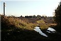
A public footpath, viewed from Thorley Lane West
Image: © Robert Edwards
Taken: 29 Oct 2008
0.21 miles
2
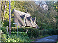
Crowscroft, Thorley Lane
A grade II listed building of the seventeenth century.
Image: © Robin Webster
Taken: 4 Nov 2014
0.22 miles
3
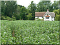
Footpath through beans and Meadow Cottage
The footpath runs from Moor Hall Lane to Butler's Hall Lane.
Image: © Robin Webster
Taken: 25 Jun 2015
0.24 miles