IMAGES TAKEN NEAR TO
Thornbera Road, BISHOP'S STORTFORD, CM23 3NN
Introduction
This page details the photographs taken nearby to Thornbera Road, CM23 3NN by members of the Geograph project.
The Geograph project started in 2005 with the aim of publishing, organising and preserving representative images for every square kilometre of Great Britain, Ireland and the Isle of Man.

There are currently over 7.5m images from over14,400 individuals and you can help contribute to the project by visiting https://www.geograph.org.uk
Image Map (Loading...)


Getting Data...Please wait
Leaflet Map data © OpenStreetMap
Images are licensed for reuse under creativecommons.org/licenses/by-sa/2.0
Notes
- Clicking on the map will re-center to the selected point.
- The higher the marker number, the further away the image location is from the centre of the postcode.
Image Listing (5 Images Found)
Images are licensed for reuse under creativecommons.org/licenses/by-sa/2.0
Image
Details
Distance
1
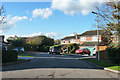
A branch of Appleton Fields
This has houses 1 to 9. Many of the houses on Appleton Fields are reached only via pathways.
Image: © Robin Webster
Taken: 4 Nov 2014
0.20 miles
2

Bishop's Stortford from the air
Most of the town can be seen in this view from a Birmingham bound flight from Prague.
Image: © Thomas Nugent
Taken: 11 Feb 2022
0.21 miles
3
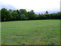
Field off Cox's Gardens
See here Image for conditions of use.
Image: © Thomas Nugent
Taken: 12 Aug 2011
0.22 miles
4
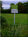
Warning notice
On a piece of open ground at Cox's Gardens.
Image: © Thomas Nugent
Taken: 12 Aug 2011
0.24 miles
5
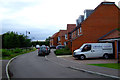
Cox's Gardens
New housing off Elizabeth Road.
Image: © Thomas Nugent
Taken: 12 Aug 2011
0.24 miles