IMAGES TAKEN NEAR TO
Thorley Hill, BISHOP'S STORTFORD, CM23 3NA
Introduction
This page details the photographs taken nearby to Thorley Hill, CM23 3NA by members of the Geograph project.
The Geograph project started in 2005 with the aim of publishing, organising and preserving representative images for every square kilometre of Great Britain, Ireland and the Isle of Man.

There are currently over 7.5m images from over14,400 individuals and you can help contribute to the project by visiting https://www.geograph.org.uk
Image Map
Images are licensed for reuse under creativecommons.org/licenses/by-sa/2.0
Notes
- Clicking on the map will re-center to the selected point.
- The higher the marker number, the further away the image location is from the centre of the postcode.
Image Listing (15 Images Found)
Images are licensed for reuse under creativecommons.org/licenses/by-sa/2.0
Image
Details
Distance
1
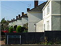
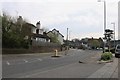
Rhodes Avenue
Viewed from Zambesi Road.
Image: © Thomas Nugent
Taken: 19 Oct 2007
0.14 miles
2
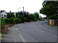
Havers Lane
A pleasant residential road between South Street and Thorley Hill.
Image: © Thomas Nugent
Taken: 12 Aug 2011
0.15 miles
3
Norfolk Way
Looking into Norfolk Way from Havers Lane.
Image: © Thomas Nugent
Taken: 12 Aug 2011
0.19 miles
4

Facelift
The Jobcentre building on South Road gets a new skin.
Image: © Thomas Nugent
Taken: 27 Feb 2008
0.19 miles
7
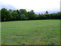
Field off Cox's Gardens
See here Image for conditions of use.
Image: © Thomas Nugent
Taken: 12 Aug 2011
0.22 miles
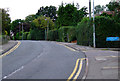
8
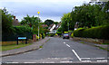
Beechlands
At the junction with Cemetery Road.
Image: © Thomas Nugent
Taken: 12 Aug 2011
0.22 miles
9
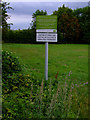
Warning notice
On a piece of open ground at Cox's Gardens.
Image: © Thomas Nugent
Taken: 12 Aug 2011
0.22 miles
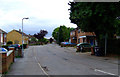
10
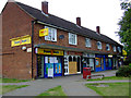
Shops at Elizabeth Road
At the top of Havers Lane.
Image: © Thomas Nugent
Taken: 12 Aug 2011
0.22 miles