IMAGES TAKEN NEAR TO
Riverside, BISHOP'S STORTFORD, CM23 3GQ
Introduction
This page details the photographs taken nearby to Riverside, CM23 3GQ by members of the Geograph project.
The Geograph project started in 2005 with the aim of publishing, organising and preserving representative images for every square kilometre of Great Britain, Ireland and the Isle of Man.

There are currently over 7.5m images from over14,400 individuals and you can help contribute to the project by visiting https://www.geograph.org.uk
Image Map (Loading...)


Getting Data...Please wait
Leaflet Map data © OpenStreetMap
Images are licensed for reuse under creativecommons.org/licenses/by-sa/2.0
Notes
- Clicking on the map will re-center to the selected point.
- The higher the marker number, the further away the image location is from the centre of the postcode.
Image Listing (314 Images Found)
Images are licensed for reuse under creativecommons.org/licenses/by-sa/2.0
Image
Details
Distance
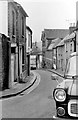
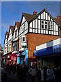
1
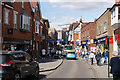
Potter Street
The traditional main shopping street through Bishop's Stortford. It is open to one-way traffic but is narrow.
Image: © Bill Boaden
Taken: 2 Sep 2019
0.02 miles
2
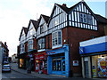
Potter Street
At the junction with Apton Road.
Image: © Thomas Nugent
Taken: 31 May 2011
0.03 miles
3
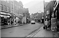
South Street, Bishop's Stortford
Much has changed along the main shopping street since 1972.
Notable in this shot is the flat-roofed brick building on the right which was built for Sainsbury's, Bishop's Stortford's first large supermarket. I see in 2010 it housed Card Factory. Compare with Thomas Nugent's 2007 shot http://www.geograph.org.uk/photo/546308 when it housed a branch of Wallis.
Good to see the large building on the left has survived although all the shops have changed there.
Image: © Penny Mayes
Taken: 1 Jan 1972
0.03 miles
4
Potter Street
Looking up the hill towards Jackson Square. The red fronted shop was once Woolworths.
Image: © Thomas Nugent
Taken: 31 May 2011
0.03 miles
5
Church Street, Bishop's Stortford
Looking down towards its junction with Potter Street. The large building on the right with the stripes in the brickwork is the Technical Institute. This has since been demolished and the current view is shown here http://www.stortfordhistory.co.uk/guide15/church_street.html .
Image: © Penny Mayes
Taken: 1 Jan 1972
0.03 miles
6
South Street
Looking uphill towards Potter Street.
Image: © Thomas Nugent
Taken: 3 Sep 2007
0.03 miles
7
Jackson Square
A shopping mall on Potter Street.
Image: © Thomas Nugent
Taken: 31 May 2011
0.03 miles
8
Potter Street
At the end of South Street.
Image: © Thomas Nugent
Taken: 31 May 2011
0.03 miles
9
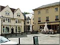
Market Square
Viewed from Market Street.
Image: © Thomas Nugent
Taken: 3 Sep 2007
0.04 miles
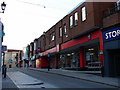
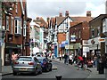
10
South Street
A busy and narrow shopping street in central Bishop's Stortford. On Saturday morning it was lined with market traders' stalls.
http://www.bishopsstortfordtc.gov.uk/
Image: © Colin Smith
Taken: 12 Dec 2009
0.04 miles