IMAGES TAKEN NEAR TO
Dane Street, BISHOP'S STORTFORD, CM23 3BX
Introduction
This page details the photographs taken nearby to Dane Street, CM23 3BX by members of the Geograph project.
The Geograph project started in 2005 with the aim of publishing, organising and preserving representative images for every square kilometre of Great Britain, Ireland and the Isle of Man.

There are currently over 7.5m images from over14,400 individuals and you can help contribute to the project by visiting https://www.geograph.org.uk
Image Map (Loading...)


Getting Data...Please wait
Leaflet Map data © OpenStreetMap
Images are licensed for reuse under creativecommons.org/licenses/by-sa/2.0
Notes
- Clicking on the map will re-center to the selected point.
- The higher the marker number, the further away the image location is from the centre of the postcode.
Image Listing (310 Images Found)
Images are licensed for reuse under creativecommons.org/licenses/by-sa/2.0
Image
Details
Distance
1
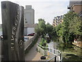
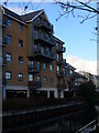
Riverside House
On The Causeway, with Westmill Foods mill in the background. This is the Bishop's Stortford Register Office.
Image: © Thomas Nugent
Taken: 3 Sep 2007
0.02 miles
2
River Stort
The bridge carries The Causeway over the river.
Image: © Thomas Nugent
Taken: 26 Feb 2009
0.02 miles
3
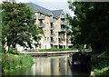
Riverside Bishop's Stortford
View of modern apartment block from the towpath on the eastern bank of the Stort. This is the head of navigation.
http://www.bishopsstortfordtc.gov.uk/
Image: © Colin Smith
Taken: 12 Dec 2009
0.02 miles
4
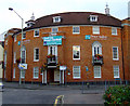
Price Bailey
Award winning chartered accountants at the corner of Hockerill Street and Dane Street.
Image: © Thomas Nugent
Taken: 12 Aug 2011
0.02 miles
5
River Stort
Viewed from the bridge at The Causeway.
Image: © Thomas Nugent
Taken: 26 Feb 2009
0.02 miles
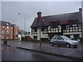
6
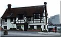
Riverside House, Bishop's Stortford
Bishop's Stortford Register Office in a mock Tudor building next to the River Stort.
Image: © JThomas
Taken: 6 Jul 2019
0.03 miles
7
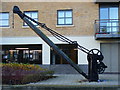
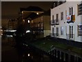
Old Crane, Bishop's Stortford
At the former wharf on the west bank of the Stort in the town centre. Bishop's Stortford takes its name from "Esterteferd" or Staorta's ford in Old English. The crane stands at the head of the Stort Navigation, an arm of the Lee Navigation. Narrowboats, not barges, sometimes reach here now.
http://www.bishopsstortfordtc.gov.uk/
Image: © Colin Smith
Taken: 12 Dec 2009
0.03 miles
8
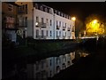
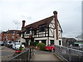
The Causeway at the junction of Dane Street
Image: © David Howard
Taken: 25 Apr 2012
0.03 miles