IMAGES TAKEN NEAR TO
Adderley Road, BISHOP'S STORTFORD, CM23 3AX
Introduction
This page details the photographs taken nearby to Adderley Road, CM23 3AX by members of the Geograph project.
The Geograph project started in 2005 with the aim of publishing, organising and preserving representative images for every square kilometre of Great Britain, Ireland and the Isle of Man.

There are currently over 7.5m images from over14,400 individuals and you can help contribute to the project by visiting https://www.geograph.org.uk
Image Map
Images are licensed for reuse under creativecommons.org/licenses/by-sa/2.0
Notes
- Clicking on the map will re-center to the selected point.
- The higher the marker number, the further away the image location is from the centre of the postcode.
Image Listing (318 Images Found)
Images are licensed for reuse under creativecommons.org/licenses/by-sa/2.0
Image
Details
Distance
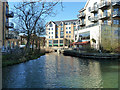
3
River Stort
The bridge carries The Causeway over the river.
Image: © Thomas Nugent
Taken: 26 Feb 2009
0.02 miles
4
River Stort
Viewed from the bridge at The Causeway.
Image: © Thomas Nugent
Taken: 26 Feb 2009
0.02 miles
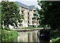
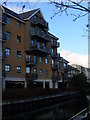
5
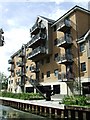
Riverside flats
By the Stort. Note the riverside hoist. See also Image
Image: © Thomas Nugent
Taken: 3 Sep 2007
0.02 miles
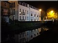
6
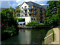
River Stort at Bishop's Stortford
Dining al fresco in the warm spring sunshine.
Image: © Thomas Nugent
Taken: 9 May 2011
0.02 miles
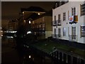
7
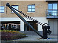
Old Crane, Bishop's Stortford
At the former wharf on the west bank of the Stort in the town centre. Bishop's Stortford takes its name from "Esterteferd" or Staorta's ford in Old English. The crane stands at the head of the Stort Navigation, an arm of the Lee Navigation. Narrowboats, not barges, sometimes reach here now.
http://www.bishopsstortfordtc.gov.uk/
Image: © Colin Smith
Taken: 12 Dec 2009
0.03 miles
8
River Stort
Viewed from near the Station Road bridge.
Image: © Thomas Nugent
Taken: 19 Oct 2007
0.03 miles
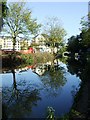
9
Truncated end of River Stort Navigation
The navigation once continued up to the Terminus Basin, about another 150 m beyond the visible bridge, which was not there. All is now built on.
Image: © Robin Webster
Taken: 16 Mar 2014
0.03 miles
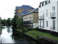
10
Riverside Bishop's Stortford
View of modern apartment block from the towpath on the eastern bank of the Stort. This is the head of navigation.
http://www.bishopsstortfordtc.gov.uk/
Image: © Colin Smith
Taken: 12 Dec 2009
0.03 miles