IMAGES TAKEN NEAR TO
Warren Street, BISHOP'S STORTFORD, CM23 2YS
Introduction
This page details the photographs taken nearby to Warren Street, CM23 2YS by members of the Geograph project.
The Geograph project started in 2005 with the aim of publishing, organising and preserving representative images for every square kilometre of Great Britain, Ireland and the Isle of Man.

There are currently over 7.5m images from over14,400 individuals and you can help contribute to the project by visiting https://www.geograph.org.uk
Image Map (Loading...)


Getting Data...Please wait
Leaflet Map data © OpenStreetMap
Images are licensed for reuse under creativecommons.org/licenses/by-sa/2.0
Notes
- Clicking on the map will re-center to the selected point.
- The higher the marker number, the further away the image location is from the centre of the postcode.
Image Listing (8 Images Found)
Images are licensed for reuse under creativecommons.org/licenses/by-sa/2.0
Image
Details
Distance
1
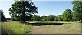
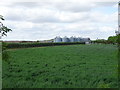
Parkland & Hoggate's Wood
Looking North from near Dane O'Coys Rd.
Image: © Glyn Baker
Taken: 24 Jun 2020
0.12 miles
2
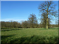
Park-like terrain
North of Dane O'Coy's Road.
Image: © Robin Webster
Taken: 16 Mar 2014
0.14 miles
3
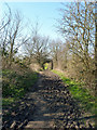
Muddy footpath
Running north-west from a corner on Dane O'Coy's Road.
Image: © Robin Webster
Taken: 16 Mar 2014
0.14 miles
7
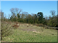
Hillside south of Dane O'Coy's Road
Looking from the footpath that runs along the bottom of the field.
Image: © Robin Webster
Taken: 16 Mar 2014
0.24 miles
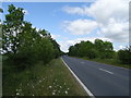
8
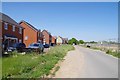
Development by Radley Lane
Once a quiet bridleway Radley lane will soon be in the middle of a housing estate.
Image: © Glyn Baker
Taken: 24 Jun 2020
0.24 miles