IMAGES TAKEN NEAR TO
Grays Court, BISHOP'S STORTFORD, CM23 2UU
Introduction
This page details the photographs taken nearby to Grays Court, CM23 2UU by members of the Geograph project.
The Geograph project started in 2005 with the aim of publishing, organising and preserving representative images for every square kilometre of Great Britain, Ireland and the Isle of Man.

There are currently over 7.5m images from over14,400 individuals and you can help contribute to the project by visiting https://www.geograph.org.uk
Image Map
Images are licensed for reuse under creativecommons.org/licenses/by-sa/2.0
Notes
- Clicking on the map will re-center to the selected point.
- The higher the marker number, the further away the image location is from the centre of the postcode.
Image Listing (160 Images Found)
Images are licensed for reuse under creativecommons.org/licenses/by-sa/2.0
Image
Details
Distance
3
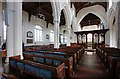
St Michael, Bishop's Stortford - Interior
Image: © John Salmon
Taken: 9 Aug 2011
0.08 miles
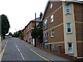
4
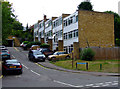
Hadham Road
How did that skip get up there?
Image: © Thomas Nugent
Taken: 12 Aug 2011
0.09 miles
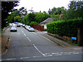
5
Chantry Road
Off Hadham Road, Opposite King Street.
Image: © Thomas Nugent
Taken: 12 Aug 2011
0.09 miles
6

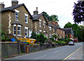
Hadham Road
Looking towards the town centre.
Image: © Thomas Nugent
Taken: 12 Aug 2011
0.10 miles
7
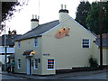
Chutney Joe
Indian style bar/diner on Hadham Road at Chantry Road.
Image: © Thomas Nugent
Taken: 31 May 2011
0.10 miles
9
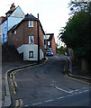
King Street
A steep winding lane off Hadham Road.
Image: © Thomas Nugent
Taken: 31 May 2011
0.11 miles
10
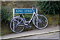
Bike on King Street
Chained to the street sign, at the bottom of the steep hill, the bike appears to have a flat front tyre.
Image: © Thomas Nugent
Taken: 12 Aug 2011
0.11 miles