IMAGES TAKEN NEAR TO
Cricketfield Lane, BISHOP'S STORTFORD, CM23 2RJ
Introduction
This page details the photographs taken nearby to Cricketfield Lane, CM23 2RJ by members of the Geograph project.
The Geograph project started in 2005 with the aim of publishing, organising and preserving representative images for every square kilometre of Great Britain, Ireland and the Isle of Man.

There are currently over 7.5m images from over14,400 individuals and you can help contribute to the project by visiting https://www.geograph.org.uk
Image Map (Loading...)


Getting Data...Please wait
Leaflet Map data © OpenStreetMap
Images are licensed for reuse under creativecommons.org/licenses/by-sa/2.0
Notes
- Clicking on the map will re-center to the selected point.
- The higher the marker number, the further away the image location is from the centre of the postcode.
Image Listing (7 Images Found)
Images are licensed for reuse under creativecommons.org/licenses/by-sa/2.0
Image
Details
Distance
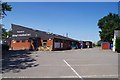
1

Bishop's Stortford Squash & Racket Ball Club
With an empty car park due to Covid-19
Image: © Glyn Baker
Taken: 24 Jun 2020
0.14 miles
2

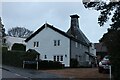
Old Cricket Pavilion, Bishop's Stortford, Herts
This is the lovely old cricket pavilion at Cricketfield Lane, Bishop's Stortford, Herts.
Image: © Dave Skinner
Taken: 9 Jul 2005
0.16 miles
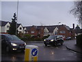
4
Bishop's Stortford RFC
BSRFC's clubhouse
Image: © Glyn Baker
Taken: 24 Jun 2020
0.18 miles
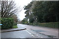
7
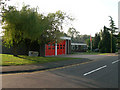
Bishop's Stortford fire and ambulance station
The station is located to the NW of the town on the A1250
Image: © John Smith
Taken: 11 Sep 2006
0.23 miles