IMAGES TAKEN NEAR TO
Old River Lane, BISHOP'S STORTFORD, CM23 2JW
Introduction
This page details the photographs taken nearby to Old River Lane, CM23 2JW by members of the Geograph project.
The Geograph project started in 2005 with the aim of publishing, organising and preserving representative images for every square kilometre of Great Britain, Ireland and the Isle of Man.

There are currently over 7.5m images from over14,400 individuals and you can help contribute to the project by visiting https://www.geograph.org.uk
Image Map (Loading...)


Getting Data...Please wait
Leaflet Map data © OpenStreetMap
Images are licensed for reuse under creativecommons.org/licenses/by-sa/2.0
Notes
- Clicking on the map will re-center to the selected point.
- The higher the marker number, the further away the image location is from the centre of the postcode.
Image Listing (251 Images Found)
Images are licensed for reuse under creativecommons.org/licenses/by-sa/2.0
Image
Details
Distance
1
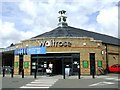
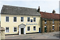
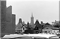
Waitrose supermarket
Perhaps the brick finished curved design is intended to complement the nearby United Reformed Church Image
Image: © Thomas Nugent
Taken: 3 Sep 2007
0.03 miles
2
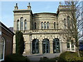
Water Lane, United Reformed Church
A very unusual looking church in the centre of Bishop's Stortford. It was opened in 1860 and designed by W.F.Poulton in the 'Italianate Style', but has a lovely bright interior.
Image: © Melvyn Cousins
Taken: 22 Mar 2006
0.03 miles
3
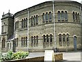
United Reformed Church
Rear view of this church on Water Lane. See Image for some historical information.
Image: © Thomas Nugent
Taken: 3 Sep 2007
0.03 miles
4
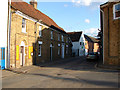
Water Lane
At the junction with Barrett Lane.
Image: © Thomas Nugent
Taken: 31 May 2011
0.03 miles
5
The Guild House, Water Lane
An 18th century house with an earlier timber frame. Listing http://www.britishlistedbuildings.co.uk/en-160979-guild-house-bishop-s-stortford-hertfords#.V2FyZnjFvVo
Now an Estate Agents.
Image: © Des Blenkinsopp
Taken: 29 Jun 2015
0.03 miles
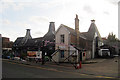
6
Coopers Garden Centre
At the junction of Bridge Street and Old River Lane.
Image: © Thomas Nugent
Taken: 3 Sep 2007
0.03 miles
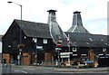
7
Maltings on Bridge Street, Bishop's Stortford, Hertfordshire
Grade II listed.
Image: © Oast House Archive
Taken: 15 Aug 2009
0.03 miles
8
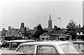
View across Handscomb's store to St Michael's church from the Causeway car park
I gather that Handscomb's, the hardware store housed in this old malt house, is now Coopers having been Maslens in between - see http://www.stortfordhistory.co.uk/guide1/coopers-store/ .
Image: © Penny Mayes
Taken: 1 Jan 1972
0.03 miles
9
View across Handscomb's store to St Michael's church from the Causeway car park
With part of the recently built Charrington House on the left.
Image: © Penny Mayes
Taken: 1 Jan 1972
0.04 miles
10
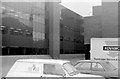
Charrington House
Charrington House was built as the head office of fuel and transport group Charrington Gardner Locket & Co Ltd. The reflected crane is working on the construction of Jackson Square in Bridge Street.
Charrington House now houses Council offices.
Image: © Penny Mayes
Taken: 1 Jan 1972
0.04 miles