IMAGES TAKEN NEAR TO
Stansted Road, BISHOP'S STORTFORD, CM23 2DT
Introduction
This page details the photographs taken nearby to Stansted Road, CM23 2DT by members of the Geograph project.
The Geograph project started in 2005 with the aim of publishing, organising and preserving representative images for every square kilometre of Great Britain, Ireland and the Isle of Man.

There are currently over 7.5m images from over14,400 individuals and you can help contribute to the project by visiting https://www.geograph.org.uk
Image Map (Loading...)


Getting Data...Please wait
Leaflet Map data © OpenStreetMap
Images are licensed for reuse under creativecommons.org/licenses/by-sa/2.0
Notes
- Clicking on the map will re-center to the selected point.
- The higher the marker number, the further away the image location is from the centre of the postcode.
Image Listing (54 Images Found)
Images are licensed for reuse under creativecommons.org/licenses/by-sa/2.0
Image
Details
Distance
1
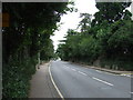
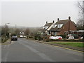
Stansted Road
View looking north from All Saints Road.
Image: © Thomas Nugent
Taken: 19 Aug 2008
0.06 miles
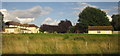
2
Flat roofed houses
On Cherry Gardens off Stansted Road.
Image: © Thomas Nugent
Taken: 19 Aug 2008
0.11 miles
3
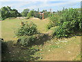
On Waytemore Castle, Bishop?s Stortford
There is not much left of the castle, just the mound and a few ruins.
Image: © Peter S
Taken: 31 Aug 2016
0.11 miles
4
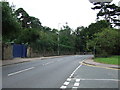
Stansted Road
View looking south from All Saints Close.
Image: © Thomas Nugent
Taken: 19 Aug 2008
0.13 miles
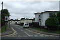
5
Kings Court, Bishop's Stortford
Kings Court is a residential road in the Hertfordshire town of Bishop's Stortford.
Image: © Malc McDonald
Taken: 25 Jan 2020
0.14 miles
6
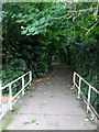
Public footpath
Leads off Stortford Hall Park, past the Anglo-European College.
Image: © Thomas Nugent
Taken: 19 Aug 2008
0.15 miles
8
House, Bishop's Stortford
A large house on Dolphin Way on the north side of town seen from a train on the line between Stansted Mountfitchet and Bishop's Stortford.
Image: © Derek Harper
Taken: 2 Aug 2012
0.15 miles
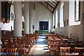
9
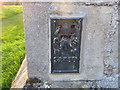
Ordnance Survey Flush Bracket S2436
This can be found on the wall of All Saints Church, Bishop's Stortford.
For more detail see : http://www.bench-marks.org.uk/bm11067
Image: © Peter Wood
Taken: 23 Feb 2015
0.15 miles
10
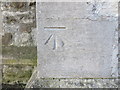
Ordnance Survey Cut Mark
This can be found on the wall of All saints Church, Bishop's Stortford.
For more detail see : http://www.bench-marks.org.uk/bm68591
Image: © Peter Wood
Taken: 23 Feb 2015
0.15 miles