IMAGES TAKEN NEAR TO
Stansted Road, BISHOP'S STORTFORD, CM23 2BT
Introduction
This page details the photographs taken nearby to Stansted Road, CM23 2BT by members of the Geograph project.
The Geograph project started in 2005 with the aim of publishing, organising and preserving representative images for every square kilometre of Great Britain, Ireland and the Isle of Man.

There are currently over 7.5m images from over14,400 individuals and you can help contribute to the project by visiting https://www.geograph.org.uk
Image Map
Images are licensed for reuse under creativecommons.org/licenses/by-sa/2.0
Notes
- Clicking on the map will re-center to the selected point.
- The higher the marker number, the further away the image location is from the centre of the postcode.
Image Listing (13 Images Found)
Images are licensed for reuse under creativecommons.org/licenses/by-sa/2.0
Image
Details
Distance
1
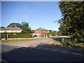
Oaklands Park at the junction of Stansted Road
Image: © David Howard
Taken: 27 Aug 2017
0.05 miles
2
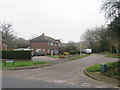
Oaklands Park, Bishop's Stortford
Oaklands Park is a residential road on the outskirts of Bishop's Stortford, in Hertfordshire.
Image: © Malc McDonald
Taken: 25 Jan 2020
0.06 miles
3
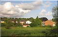
Housing near Bishop's Stortford
The houses left of centre are on Denny Crescent; the house on the right is on Aynsworth Avenue. Taken from a train on the line between Stansted Mountfitchet and Bishop's Stortford as it crosses a meadow close to the River Stort.
Image: © Derek Harper
Taken: 2 Aug 2012
0.06 miles
4
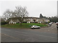
Collins Cross, Bishop's Stortford
A crescent of semi-detached houses on Collins Cross, a residential road on the outskirts of Bishop's Stortford.
Image: © Malc McDonald
Taken: 25 Jan 2020
0.07 miles
5
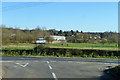
View across Stort valley
Looking from the end of Farnham Road towards an industrial area on the northern fringes of Bishop's Stortford.
Image: © Robin Webster
Taken: 16 Mar 2014
0.14 miles
6
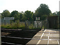
Clear to cross
The unmanned crossing of the line used by the Stansted Express at Cannons Mill Lane, Bishop's Stortford
Image: © John Smith
Taken: 11 Sep 2006
0.17 miles
7
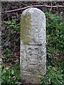
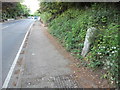
Old Milestone by the B1383, Stansted Road, Bishop's Stortford
Carved stone post by the B1383, in parish of Bishop's Stortford (East Hertfordshire District), Stansted Road, by No. 200, on grass bank, on East side of road. Hockerill stone, erected by the Hockerill turnpike trust in the 19th century.
Inscription reads:-
29
(To London)
Carved benchmark on lower face.
Hertfordshire HER & St Albans UAD.
HHER Number: 11591 https://www.heritagegateway.org.uk/Gateway/Results_Single.aspx?uid=MHT11591&resourceID=1008
Milestone Society National ID: HE_BSGC29
Image: © MW Hallett
Taken: 26 Apr 2003
0.19 miles
8
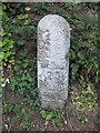
Old Milepost
Old milepost at Bishop's Stortford, Essex on what was the old A11. For overall view see http://www.geograph.org.uk/photo/2454637
Image: © Keith Evans
Taken: 12 May 2011
0.19 miles
9
Old Milepost
Old milepost at Bishop's Stortford, Essex on what was the old A.11. For close up view see http://www.geograph.org.uk/photo/2454632
Image: © Keith Evans
Taken: 12 May 2011
0.19 miles
10
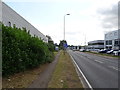
Stansted Road, Bishop's Stortford
The B1383.
Image: © JThomas
Taken: 20 Jul 2019
0.21 miles