IMAGES TAKEN NEAR TO
Walnut Tree Lane, Farnham Road, BISHOP'S STORTFORD, CM23 1JF
Introduction
This page details the photographs taken nearby to Walnut Tree Lane, Farnham Road, CM23 1JF by members of the Geograph project.
The Geograph project started in 2005 with the aim of publishing, organising and preserving representative images for every square kilometre of Great Britain, Ireland and the Isle of Man.

There are currently over 7.5m images from over14,400 individuals and you can help contribute to the project by visiting https://www.geograph.org.uk
Image Map
Images are licensed for reuse under creativecommons.org/licenses/by-sa/2.0
Notes
- Clicking on the map will re-center to the selected point.
- The higher the marker number, the further away the image location is from the centre of the postcode.
Image Listing (8 Images Found)
Images are licensed for reuse under creativecommons.org/licenses/by-sa/2.0
Image
Details
Distance
1
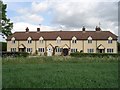
Walnut Tree Cottages
Ex farm workers cottages from The Wickham Hall Estate.
Image: © Debra Lehner
Taken: 20 May 2009
0.01 miles
2
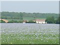
Walnut Tree Cottages
Taken from Bailey Hill's Woods across the linseed.
Image: © Debra Lehner
Taken: 25 May 2009
0.01 miles
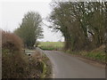
3
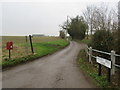
Walnut Tree Lane, near Bishop's Stortford
Walnut Tree Lane is a minor road providing access to a couple of dwellings in the north Essex countryside. The wooden signpost indicates the route of a bridleway along the lane.
Image: © Malc McDonald
Taken: 25 Jan 2020
0.16 miles
4
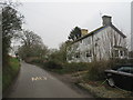
Houses near Farnham
A pair of houses on a minor lane in the north Essex countryside.
Image: © Malc McDonald
Taken: 25 Jan 2020
0.19 miles
6
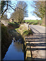
Deep roadside ditch
Complete with duck.
Image: © Robin Webster
Taken: 16 Mar 2014
0.21 miles
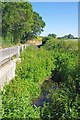
7
Farnham Road and Bourne Brook, near Bishop's Stortford
Farnham Road is a minor road through countryside on the Hertfordshire and Essex border. In a ditch to the left of the road is Bourne Brook, a tributary of the River Stort.
Image: © Malc McDonald
Taken: 25 Jan 2020
0.22 miles
8
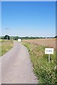
Doomed Field and Bridleway
The white trailer on the verge (a workers welfare van), fallow field and plethora of 25 MPH signs not to mention the Image seem to indicate the land between the bridleway and A120 will soon be a housing estate.
Image: © Glyn Baker
Taken: 24 Jun 2020
0.23 miles