IMAGES TAKEN NEAR TO
Tilekiln Green, BISHOP'S STORTFORD, CM22 7TQ
Introduction
This page details the photographs taken nearby to Tilekiln Green, CM22 7TQ by members of the Geograph project.
The Geograph project started in 2005 with the aim of publishing, organising and preserving representative images for every square kilometre of Great Britain, Ireland and the Isle of Man.

There are currently over 7.5m images from over14,400 individuals and you can help contribute to the project by visiting https://www.geograph.org.uk
Image Map (Loading...)


Getting Data...Please wait
Leaflet Map data © OpenStreetMap
Images are licensed for reuse under creativecommons.org/licenses/by-sa/2.0
Notes
- Clicking on the map will re-center to the selected point.
- The higher the marker number, the further away the image location is from the centre of the postcode.
Image Listing (16 Images Found)
Images are licensed for reuse under creativecommons.org/licenses/by-sa/2.0
Image
Details
Distance
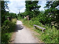
1
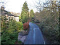
View from the bridge
Looking down on the Great Hallingbury road from the former railway bridge on the abandoned Bishop's Stortford - Braintree route.
Image: © Robin Webster
Taken: 11 Jan 2015
0.01 miles
2
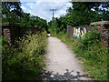
The end of the Flitch Way at Start Hill
The Flitch Way begins and ends here at its western end, where cars can be parked in a small lay-by. The Flitch Way is 15 miles long and follows the former Bishop's Stortford to Braintree railway. Its name comes from a medieval ceremony, which originated in Little Dunmow and which still takes place every four years. The ceremony involved married couples trying to prove that they hadn't argued for a year and a day, and if successful they were awarded with a Flitch (or side) of bacon. For a leaflet about The Flitch Way see http://www.essexhighways.org/Uploads/Files/flitchway.pdf
The railway was opened on 22nd February 1869 and was closed to passengers on 3rd May 1952. It was closed completely on 18th April 1966. For a much fuller history of the railway see http://www.disused-stations.org.uk/t/takeley/ Takeley station was the first station reached along the line to the east. The bridge just ahead can be seen from below at http://www.geograph.org.uk/photo/4544177
Image: © Marathon
Taken: 27 Jun 2015
0.02 miles
3
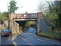
Old railway bridge, Start Hill
The old Bishop's Stortford - Braintree railway crossed the road through Great Hallingbury here. It is now used by the Flitch Way trail, with the western end access just to the left.
Image: © Robin Webster
Taken: 11 Jan 2015
0.02 miles
4
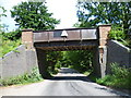
The start of the Flitch Way at Start Hill
The Flitch Way begins here at its western end, and cars can be parked in a small lay-by on the left. The Flitch Way is 15 miles long and follows the former Bishop's Stortford to Braintree railway. Its name comes from a medieval ceremony, which originated in Little Dunmow and which still takes place every four years. The ceremony involved married couples trying to prove that they hadn't argued for a year and a day, and if successful they were awarded with a Flitch (or side) of bacon. For a leaflet about The Flitch Way see http://www.essexhighways.org/Uploads/Files/flitchway.pdf
The railway was opened on 22nd February 1869 and was closed to passengers on 3rd May 1952. It was closed completely on 18th April 1966. For a much fuller history of the railway see http://www.disused-stations.org.uk/t/takeley/ Takeley station was the first station reached along the line to the east.
Image: © Marathon
Taken: 27 Jun 2015
0.02 miles
5
The end of the Flitch Way at Start Hill
The Flitch Way begins and ends here at its western end, where cars can be parked in a small lay-by. The Flitch Way is 15 miles long and follows the former Bishop's Stortford to Braintree railway. Its name comes from a medieval ceremony, which originated in Little Dunmow and which still takes place every four years. The ceremony involved married couples trying to prove that they hadn't argued for a year and a day, and if successful they were awarded with a Flitch (or side) of bacon. For a leaflet about The Flitch Way see http://www.essexhighways.org/Uploads/Files/flitchway.pdf
The railway was opened on 22nd February 1869 and was closed to passengers on 3rd May 1952. It was closed completely on 18th April 1966. For a much fuller history of the railway see http://www.disused-stations.org.uk/t/takeley/ Takeley station was the first station reached along the line to the east. The bridge just ahead can be seen from below at http://www.geograph.org.uk/photo/4544177
Image: © Marathon
Taken: 27 Jun 2015
0.02 miles
6
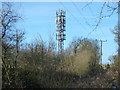
Telecommunications mast, Start Hill
Viewed from the Flitch Way, running along the former Bishop's Stortford - Braintree railway.
Image: © Robin Webster
Taken: 11 Jan 2015
0.10 miles
7
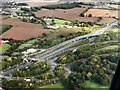
The M11 / A120 interchange complex
Taken from a Jet2 flight which had just taken off from Stansted
Image: © Richard Humphrey
Taken: 11 Oct 2020
0.15 miles
8
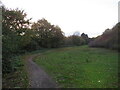
National Cycle Network route 16 near Stansted Airport
This path forms part of the route of National Cycle Network route 16 as it skirts to the south of Stansted Airport. This image was taken at dusk on a late October day.
Image: © Malc McDonald
Taken: 29 Oct 2022
0.17 miles
9

Roundabout above the M11 near Stansted
Left lane for the motorway southbound, straight on for Bishop's Stortford and the bypass.
Image: © David Howard
Taken: 25 Apr 2012
0.21 miles
10
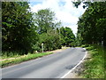
Road alongside The Great Hallingbury Manor Hotel
The lake of the hotel is just to the right here.
Image: © Marathon
Taken: 27 Jun 2015
0.23 miles