IMAGES TAKEN NEAR TO
New Bury Meadows, BISHOP'S STORTFORD, CM22 7LQ
Introduction
This page details the photographs taken nearby to New Bury Meadows, CM22 7LQ by members of the Geograph project.
The Geograph project started in 2005 with the aim of publishing, organising and preserving representative images for every square kilometre of Great Britain, Ireland and the Isle of Man.

There are currently over 7.5m images from over14,400 individuals and you can help contribute to the project by visiting https://www.geograph.org.uk
Image Map (Loading...)


Getting Data...Please wait
Leaflet Map data © OpenStreetMap
Images are licensed for reuse under creativecommons.org/licenses/by-sa/2.0
Notes
- Clicking on the map will re-center to the selected point.
- The higher the marker number, the further away the image location is from the centre of the postcode.
Image Listing (37 Images Found)
Images are licensed for reuse under creativecommons.org/licenses/by-sa/2.0
Image
Details
Distance
1
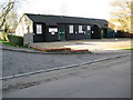
Hatfield Broad Oak: Village Hall
The Village Hall is on the west side of the road known as Cage End.
Image: © Nigel Cox
Taken: 9 Jan 2008
0.02 miles
3
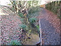
Hatfield Broad Oak: Mus Brook
Mus Brook, pictured here on the south side of Cage End Close, is a short tributary of the much larger Pincey Brook. Some minor protection work has been necessary on the right to preserve the bank of the public footpath.
Image: © Nigel Cox
Taken: 9 Jan 2008
0.10 miles
4
Village pump and main street, Hatfield Broad Oak.
The village pump is a feature of many rural villages in Essex. The signpost is a fairly new one made in a traditional style.
Image: © John V Nicholls
Taken: 22 Nov 2005
0.12 miles
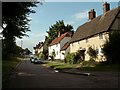
5
Cage End, Hatfield Broad Oak, Essex
The village was once a prominent market town and in ancient times known as Hatfield Regis. The manor of Hatfield fell into the hands of William the 1st following the conquest, and supposedly renamed with its Royal title to distinguish it from Hatfield Peverel in the Eastern half of the county.
Image: © Derek Voller
Taken: 1 Mar 2012
0.15 miles
7
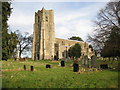
Hatfield Broad Oak: The Church of St Mary the Virgin
A mid-day Wednesday and the bell ringers were producing a peal.
Image: © Nigel Cox
Taken: 9 Jan 2008
0.18 miles
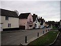
8
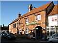
Hatfield Broad Oak: The Cock Inn
The large arched entranceway reveals The Cock Inn's past as a coaching inn.
Image: © Nigel Cox
Taken: 9 Jan 2008
0.18 miles
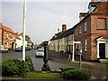
9
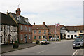
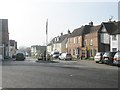
Hatfield Broad Oak
Taken in High Street. The road to the left of the flagstaff is Cage End.
Image: © David Kemp
Taken: 6 Apr 2010
0.18 miles
10
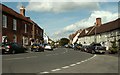
Hatfield Broad Oak's High Street
This is the B183.
Image: © Robert Edwards
Taken: 10 Jul 2008
0.18 miles