IMAGES TAKEN NEAR TO
Rush Lane, BISHOP'S STORTFORD, CM22 6TF
Introduction
This page details the photographs taken nearby to Rush Lane, CM22 6TF by members of the Geograph project.
The Geograph project started in 2005 with the aim of publishing, organising and preserving representative images for every square kilometre of Great Britain, Ireland and the Isle of Man.

There are currently over 7.5m images from over14,400 individuals and you can help contribute to the project by visiting https://www.geograph.org.uk
Image Map
Images are licensed for reuse under creativecommons.org/licenses/by-sa/2.0
Notes
- Clicking on the map will re-center to the selected point.
- The higher the marker number, the further away the image location is from the centre of the postcode.
Image Listing (12 Images Found)
Images are licensed for reuse under creativecommons.org/licenses/by-sa/2.0
Image
Details
Distance
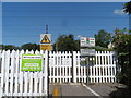
1
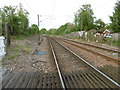
View from the foot crossing over the railway at Fullers End, near Elsenham
The railway line to Cambridge was opened by the Eastern Counties Railway on 30th July 1845. Robin Hood Road to the west of the railway presumably once linked up with Tye Green Road to the east of it. Now it is just a foot crossing known as Fullers End Footpath Crossing.
This looks in the down direction. The next station in this direction is Elsenham. For the view in the up direction see http://www.geograph.org.uk/photo/4952084
Image: © Marathon
Taken: 14 May 2016
0.07 miles
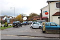
2
Railway foot crossing at Fuller's End, Elsenham
Looking north up the West Anglia Mainline.
Image: © Bikeboy
Taken: 21 Jun 2014
0.08 miles
3
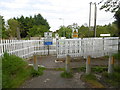
Foot crossing over the railway at Fullers End, near Elsenham
The railway line to Cambridge was opened by the Eastern Counties Railway on 30th July 1845. Robin Hood Road to the west of the railway presumably once linked up with Tye Green Road to the east of it. Now it is just a foot crossing known as Fullers End Footpath Crossing. This view is from Robin Hood Road.
Image: © Marathon
Taken: 14 May 2016
0.08 miles
4
Railway foot crossing at Fuller's End, Elsenham
The footpath crosses the West Anglia Mainline here. (Looking west).
Image: © Bikeboy
Taken: 21 Jun 2014
0.09 miles
5
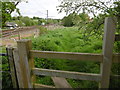
Footpath alongside the railway near Elsenham
The railway line to Cambridge was opened by the Eastern Counties Railway on 30th July 1845. Robin Hood Road to the west of the railway presumably once linked up with Tye Green Road to the east of it. Now it is just a foot crossing known as Fullers End Footpath Crossing.
This footpath leads away from Robin Hood Road, close to the crossing.
Image: © Marathon
Taken: 14 May 2016
0.09 miles
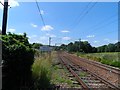
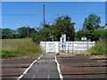
6
View from the foot crossing over the railway at Fullers End, near Elsenham
The railway line to Cambridge was opened by the Eastern Counties Railway on 30th July 1845. Robin Hood Road to the west of the railway presumably once linked up with Tye Green Road to the east of it. Now it is just a foot crossing known as Fullers End Footpath Crossing.
This looks in the up direction. The next stations in this direction are either Stansted Mounfitchet or Stansted Airport.
Image: © Marathon
Taken: 14 May 2016
0.10 miles
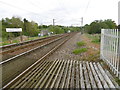
7
Railway foot crossing at Fuller's End, Elsenham
Looking east. The crossing is marked as a foot bridge on the O.S. map (FB), but there isn't one.
Image: © Bikeboy
Taken: 21 Jun 2014
0.11 miles
8
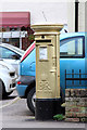
Gold Post Box, Robin Hood Road
Painted gold to celebrate Ben Maher's Gold medal for the Equestrian Team Jumping during the London 2012 Olympic Games.
Image: © Oast House Archive
Taken: 1 Nov 2012
0.16 miles
9
Gold Post Box, Robin Hood Road
Painted gold to celebrate Ben Maher's Gold medal for the Equestrian Team Jumping during the London 2012 Olympic Games.
Image: © Oast House Archive
Taken: 1 Nov 2012
0.16 miles