IMAGES TAKEN NEAR TO
Sycamore Close, BISHOP'S STORTFORD, CM22 6QA
Introduction
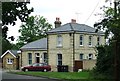
This page details the photographs taken nearby to Sycamore Close, CM22 6QA by members of the Geograph project.
The Geograph project started in 2005 with the aim of publishing, organising and preserving representative images for every square kilometre of Great Britain, Ireland and the Isle of Man.

There are currently over 7.5m images from over14,400 individuals and you can help contribute to the project by visiting https://www.geograph.org.uk
Image Map
Images are licensed for reuse under creativecommons.org/licenses/by-sa/2.0
Notes
- Clicking on the map will re-center to the selected point.
- The higher the marker number, the further away the image location is from the centre of the postcode.
Image Listing (48 Images Found)
Images are licensed for reuse under creativecommons.org/licenses/by-sa/2.0
Image
Details
Distance
1
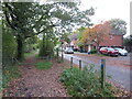
Flitch Way, Takeley, near Bishop's Stortford
Flitch Way entering the site of Takeley railway station. A modern housing development occupies the site of the former railway goods yard.
This image was taken on a late October day. Leaves were turning autumnal shades of golden yellow and falling from the trees as the winter months were approaching.
Image: © Malc McDonald
Taken: 29 Oct 2022
0.02 miles
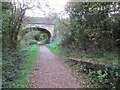
2
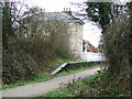
Takeley Station
Now disused. Viewed from beneath the B183 road bridge.
Image: © Thomas Nugent
Taken: 27 Feb 2007
0.02 miles
3
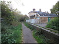
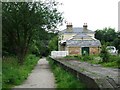
Takeley railway station
The former railway station at Takeley, in north Essex. The station closed to passengers in 1952. The building is currently disused. The former railway line is now a walking and cycling path, Flitch Way.
Image: © Malc McDonald
Taken: 29 Oct 2022
0.03 miles
4
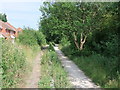
Flitch Way Country Park at Takeley Station
This view of the disused railway line is taken looking toward Braintree
Image: © PAUL FARMER
Taken: 27 Jun 2010
0.03 miles
5
Takeley Station
The line is long gone, but the building has been restored and is used by Takeley Parish Council.
See http://www.subbrit.org.uk/sb-sites/stations/t/takeley/index.shtml for a detailed history of the station and line. See also Image] and Image]
Image: © Thomas Nugent
Taken: 13 Jul 2007
0.03 miles
6
Takeley Station platform
Image: © Thomas Nugent
Taken: 13 Jul 2007
0.04 miles
7
Takeley Station
Takeley station served the Hockerill area of Takeley. Services Began on the 7 November 1910 and ended on the 3 March 1952. The station along with almost all the intermediate stations on the Bishop's Stortford-Braintree branch were little used.
Image: © PAUL FARMER
Taken: 27 Jun 2010
0.04 miles
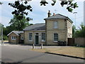
8

Takeley Station House
Looking along the Flitch Way
Image: © Glyn Baker
Taken: 29 Jun 2019
0.04 miles
9
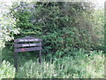
Sign: Flitch Way Country Park at Takeley Station
Image: © PAUL FARMER
Taken: 27 Jun 2010
0.04 miles
10
Flitch Way, Takeley, near Bishop's Stortford
This image of Flitch Way was taken from the site of Takeley railway station. The end of the station platform is visible to the right of the image. The bridge ahead carries a road across the former railway line.
Image: © Malc McDonald
Taken: 29 Oct 2022
0.06 miles