IMAGES TAKEN NEAR TO
Elmwood, SAWBRIDGEWORTH, CM21 9NN
Introduction
This page details the photographs taken nearby to Elmwood, CM21 9NN by members of the Geograph project.
The Geograph project started in 2005 with the aim of publishing, organising and preserving representative images for every square kilometre of Great Britain, Ireland and the Isle of Man.

There are currently over 7.5m images from over14,400 individuals and you can help contribute to the project by visiting https://www.geograph.org.uk
Image Map (Loading...)


Getting Data...Please wait
Leaflet Map data © OpenStreetMap
Images are licensed for reuse under creativecommons.org/licenses/by-sa/2.0
Notes
- Clicking on the map will re-center to the selected point.
- The higher the marker number, the further away the image location is from the centre of the postcode.
Image Listing (54 Images Found)
Images are licensed for reuse under creativecommons.org/licenses/by-sa/2.0
Image
Details
Distance
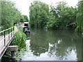
1
The Stort Navigation
Looking north to Sheering Mill Lock which is just visible amongst the trees.
Image: © Thomas Nugent
Taken: 19 Jun 2010
0.05 miles
2
The Stort Navigation
Looking north towards Sheering Mill Lock.
Image: © Thomas Nugent
Taken: 19 Jun 2010
0.05 miles
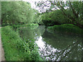
3
The Stort Navigation
Just south of Sheering Mill Lock.
Image: © Thomas Nugent
Taken: 19 Jun 2010
0.06 miles
4
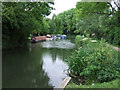
The Stort Navigation
Moorings to the south of Sheering Mill Lock.
Image: © Thomas Nugent
Taken: 19 Jun 2010
0.06 miles
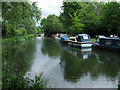
5
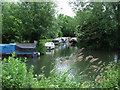
Boats on the Stort Navigation
Moored in a short inlet from the main channel, to the south of Sheering Mill Lock.
Image: © Thomas Nugent
Taken: 19 Jun 2010
0.07 miles
6
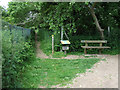
Footpath by the Stort navigation
Leads away from the river towards Elmwood.
Image: © Thomas Nugent
Taken: 19 Jun 2010
0.07 miles
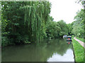
7
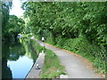
The Stort Navigation from Sheering Mill Lane
The Stort Navigation is the canalised section of the River Stort and runs for 14 miles from Bishop's Stortford downstream to its confluence with the River Lee Navigation at Rye House. Work began on 24th September 1766, under the direction of Thomas Yeoman, who was also the surveyor for the Lee Navigation, and was completed in the autumn of 1769. The navigation, which included fifteen locks, was officially opened on 24th October 1769. For a complete history of the Stort Navigation see https://en.wikipedia.org/wiki/Stort_Navigation
There is a towpath along the entire length of the navigation. It is followed by the Stort Valley Way. This view looks along the towpath from Sheering Mill Lane.
Image: © Marathon
Taken: 27 Jun 2015
0.07 miles
8
The Stort Navigation
Looking north towards Sheering Mill Lock.
Image: © Thomas Nugent
Taken: 19 Jun 2010
0.07 miles
9
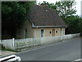
Former Lock Keeper's house
At Sheering Mill Lock on the Stort Navigation.
Image: © Thomas Nugent
Taken: 19 Jun 2010
0.09 miles
10
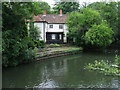
Building at Sheering Mill Lock
Possibly the mill - confirmation welcome.
Image: © Thomas Nugent
Taken: 19 Jun 2010
0.09 miles