IMAGES TAKEN NEAR TO
Sheering Mill Lane, SAWBRIDGEWORTH, CM21 9AD
Introduction
This page details the photographs taken nearby to Sheering Mill Lane, CM21 9AD by members of the Geograph project.
The Geograph project started in 2005 with the aim of publishing, organising and preserving representative images for every square kilometre of Great Britain, Ireland and the Isle of Man.

There are currently over 7.5m images from over14,400 individuals and you can help contribute to the project by visiting https://www.geograph.org.uk
Image Map
Images are licensed for reuse under creativecommons.org/licenses/by-sa/2.0
Notes
- Clicking on the map will re-center to the selected point.
- The higher the marker number, the further away the image location is from the centre of the postcode.
Image Listing (87 Images Found)
Images are licensed for reuse under creativecommons.org/licenses/by-sa/2.0
Image
Details
Distance
1
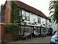
'King William IV' public house in Vantorts Road
This view is from Duckling Lane.
Image: © Robert Edwards
Taken: 3 Jun 2009
0.01 miles
2
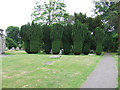
Graveyard at St Mary The Great Church
Interesting topiary.
Image: © Thomas Nugent
Taken: 19 Jun 2010
0.03 miles
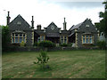
4
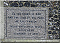
Dedication stone on the side of parish houses
Image: © Thomas Nugent
Taken: 19 Jun 2010
0.03 miles
5
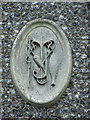
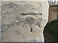
Ornament on parish houses
On the front of the building seen in these photos Image & Image Appeas to show fishing tackle and a hooked fish.
Image: © Thomas Nugent
Taken: 19 Jun 2010
0.03 miles
6
Graveyard at St Mary The Great Church
The building in the background were dedicated in 1899 "To the gloy of God and the good of the poor of this parish".
Image: © Thomas Nugent
Taken: 19 Jun 2010
0.03 miles
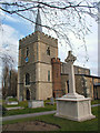
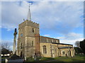
7
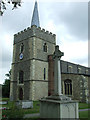
St Mary The Great
The Celtic cross is a war memorial.
The church has a good informative web site - click on this http://www.sawbridgeworthchurch.com/ to go there.
Image: © Thomas Nugent
Taken: 19 Jun 2010
0.03 miles
8
Ordnance Survey Cut Mark
This can be found on the wall of St Mary's Church, Sawbridgeworth.
For more detail see : http://www.bench-marks.org.uk/bm68581
Image: © Peter Wood
Taken: 23 Feb 2015
0.04 miles
9
The Church of St Mary at Sawbridgeworth
Viewed from the south-west.
Image: © Peter Wood
Taken: 23 Feb 2015
0.04 miles
10
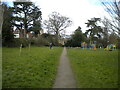
Footpath off Sheering Mill Lane, Sawbridgeworth
Passing Sheering Mill Lane Play Area on its way towards Great St Mary's church.
Image: © Richard Vince
Taken: 12 Mar 2022
0.04 miles