IMAGES TAKEN NEAR TO
High Wych, SAWBRIDGEWORTH, CM21 0LD
Introduction
This page details the photographs taken nearby to CM21 0LD by members of the Geograph project.
The Geograph project started in 2005 with the aim of publishing, organising and preserving representative images for every square kilometre of Great Britain, Ireland and the Isle of Man.

There are currently over 7.5m images from over14,400 individuals and you can help contribute to the project by visiting https://www.geograph.org.uk
Image Map (Loading...)


Getting Data...Please wait
Leaflet Map data © OpenStreetMap
Images are licensed for reuse under creativecommons.org/licenses/by-sa/2.0
Notes
- Clicking on the map will re-center to the selected point.
- The higher the marker number, the further away the image location is from the centre of the postcode.
Image Listing (3 Images Found)
Images are licensed for reuse under creativecommons.org/licenses/by-sa/2.0
Image
Details
Distance
1
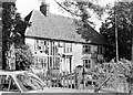
Hoskins Farm, High Wych, 1971
Looking somewhat dilapidated in the early 1970s.
Update 2021: I have just noticed this house and its outbuildings are now Grade II listed - see https://historicengland.org.uk/listing/the-list/list-entry/1220462 and https://historicengland.org.uk/listing/the-list/list-entry/1220463 so I suppose it has received a lot of restorative work since I took this photo. I can't be sure as it is blocked on Google streetview.
Image: © Penny Mayes
Taken: 1 Jan 1971
0.10 miles
2
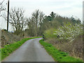
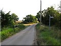
Lane with no name
No marked or mapped name, but with no premises requiring an address on it.
Image: © Robin Webster
Taken: 20 Mar 2014
0.21 miles