IMAGES TAKEN NEAR TO
Roman Rise, SAWBRIDGEWORTH, CM21 0EG
Introduction
This page details the photographs taken nearby to Roman Rise, CM21 0EG by members of the Geograph project.
The Geograph project started in 2005 with the aim of publishing, organising and preserving representative images for every square kilometre of Great Britain, Ireland and the Isle of Man.

There are currently over 7.5m images from over14,400 individuals and you can help contribute to the project by visiting https://www.geograph.org.uk
Image Map (Loading...)


Getting Data...Please wait
Leaflet Map data © OpenStreetMap
Images are licensed for reuse under creativecommons.org/licenses/by-sa/2.0
Notes
- Clicking on the map will re-center to the selected point.
- The higher the marker number, the further away the image location is from the centre of the postcode.
Image Listing (15 Images Found)
Images are licensed for reuse under creativecommons.org/licenses/by-sa/2.0
Image
Details
Distance
1
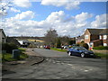
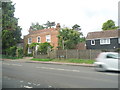
Gilders, Sawbridgeworth (2)
Seen from Hoestock Road.
Image: © Richard Vince
Taken: 12 Mar 2022
0.06 miles
2
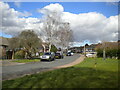
Gilders, Sawbridgeworth (1)
Seen from Hoestock Road.
Image: © Richard Vince
Taken: 12 Mar 2022
0.08 miles
3
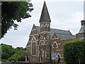
Congregational church, Sawbridgeworth
The building looks rather grand for a non-conformist church. It may be an old church of England building.
Image: © Bikeboy
Taken: 9 Jun 2013
0.12 miles
5
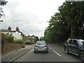
London Road, Sawbridgeworth
From Brook Road
Image: © David Howard
Taken: 13 Jun 2013
0.17 miles
6
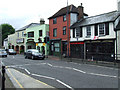
London Road
An international selection of eateries is on offer.
Image: © Thomas Nugent
Taken: 19 Jun 2010
0.20 miles
7
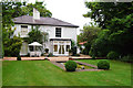
Bonks Hill House
The former residence of the family of Thomas Rivers, founder of Rivers Nursery in Sawbridgeworth, who had strong connections with Charles Darwin through his ground-breaking experiments in horticulture and plant breeding.
Image: © Roy Hammans
Taken: 20 Aug 2005
0.20 miles
8
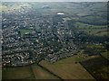
Sawbridgeworth from the air
Looking over Chalks Farm from a Stansted bound flight from Prague.
Image: © Thomas Nugent
Taken: 16 Mar 2016
0.21 miles
9
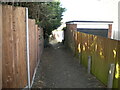
Public footpath off White Post Field, Sawbridgeworth
Leading to another footpath that skirts the western edge of the town.
Image: © Richard Vince
Taken: 12 Mar 2022
0.22 miles
10
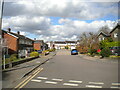
Roseacres, Sawbridgeworth (1)
At its south end, where it joins Sayesbury Avenue (right) and White Post Field (on which the photographer is standing).
Image: © Richard Vince
Taken: 12 Mar 2022
0.23 miles