IMAGES TAKEN NEAR TO
Harlow Road, SAWBRIDGEWORTH, CM21 0AL
Introduction
This page details the photographs taken nearby to Harlow Road, CM21 0AL by members of the Geograph project.
The Geograph project started in 2005 with the aim of publishing, organising and preserving representative images for every square kilometre of Great Britain, Ireland and the Isle of Man.

There are currently over 7.5m images from over14,400 individuals and you can help contribute to the project by visiting https://www.geograph.org.uk
Image Map
Images are licensed for reuse under creativecommons.org/licenses/by-sa/2.0
Notes
- Clicking on the map will re-center to the selected point.
- The higher the marker number, the further away the image location is from the centre of the postcode.
Image Listing (5 Images Found)
Images are licensed for reuse under creativecommons.org/licenses/by-sa/2.0
Image
Details
Distance
3

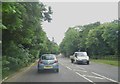
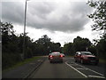
'Hand & Crown' inn, Sawbridgeworth, Herts.
Image: © Robert Edwards
Taken: 9 Aug 2006
0.13 miles
4
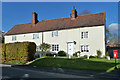
Cottages on High Wych Road
A grade II listed building of the seventeenth century.
Image: © Robin Webster
Taken: 4 Nov 2014
0.16 miles
5
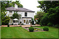
Bonks Hill House
The former residence of the family of Thomas Rivers, founder of Rivers Nursery in Sawbridgeworth, who had strong connections with Charles Darwin through his ground-breaking experiments in horticulture and plant breeding.
Image: © Roy Hammans
Taken: 20 Aug 2005
0.21 miles